Figuring out marine navigation systems can feel like learning a whole new language, especially if you’re just starting out. When I wanted to get into boating, the flood of equipment, charts, and navigation apps seemed pretty overwhelming. But understanding GPS marine navigation made a big difference for me early on, giving me confidence with every trip I planned. Here, I’ll walk you through the essentials you need to know as a beginner, and give you some practical guidance on which tools, technologies, and training will help you get started safely on the water.
What Are Marine Navigation Systems?
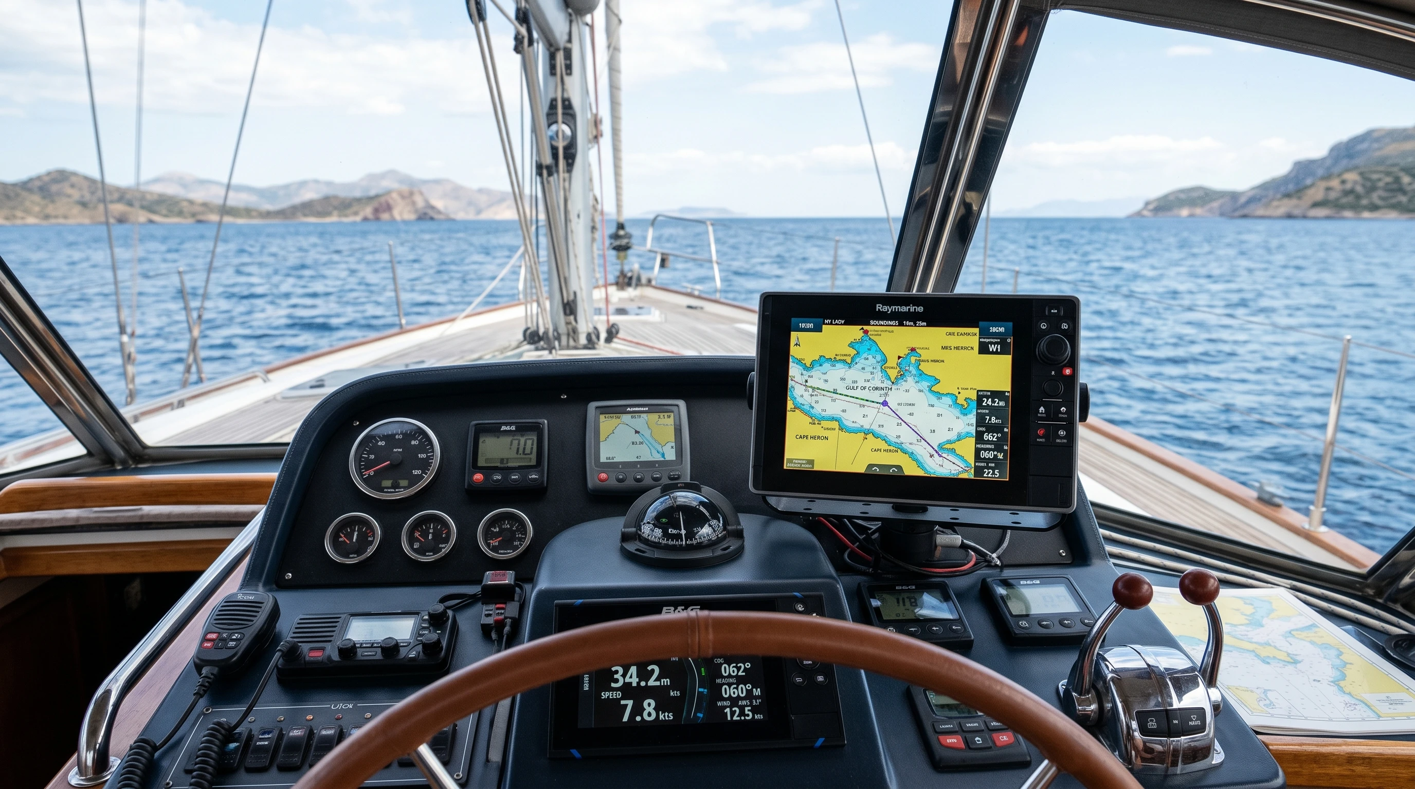
Marine navigation systems are sets of tools and technologies that help you find your position, chart your course, and reach your destination safely on water. These systems range from traditional paper charts and compasses to modern electronics like GPS plotters, AIS (Automatic Identification System), radar, and mobile apps. For me, understanding the basics took some trial and error, but once I got the hang of the main concepts, planning routes and staying aware of my surroundings became much easier.
Today, most vessels use a mix of older and newer tools. While GPS and electronic charts are the backbone for most boaters, knowing how to use manual tools comes in handy if your tech fails or loses signal. The best marine navigation tools will always be the ones you can depend on in any situation, electronic or not. Boaters and mariners have learned through experience that keeping both digital and analog methods readily available is the safest approach to navigation.
The Most Important Marine Navigation Tools for Beginners
When I first set up my navigation system, a few key pieces of equipment made all the difference. Some are classic, others are digital, but each one has a role in keeping you on course. Here’s a look at the basics you should know about:
- Compass: The classic navigation tool for determining direction. Even with advanced electronics, I always keep a magnetic compass on deck as a backup.
- Paper Marine Charts: These are detailed maps of waterways showing depths, landmarks, and hazards. They’re key for learning how to use marine navigation charts and as a fallback when electronics aren’t available.
- GPS Devices: Standalone GPS or chartplotters show your real-time position, speed, and route. Understanding GPS-based marine navigation was the biggest game-changer for me, especially when venturing into unfamiliar waters.
- Marine Navigation Apps: Smartphones and tablets can now run top marine navigation apps that sync with real charts, tides, weather, and more. They’re convenient, but I always keep my phone charged and use a waterproof case.
- Depth Sounder: Lets you track water depth in real time, helping you avoid running aground.
- Radar: Great for navigating in fog or at night, radar systems help you see other vessels or obstacles that you can’t spot visually.
- AIS (Automatic Identification System): Displays the positions and movements of nearby vessels, improving collision avoidance.
These are the main items that belong in every beginner’s navigation toolkit. As your trips become longer or conditions get more complicated, you might add wind instruments, autopilots, or even satellite communication devices. Preparing for changing conditions is crucial, having the right combination of basic and advanced equipment will keep you flexible and safe no matter where you venture.
How Marine Navigation Systems Work: Key Principles
Marine navigation systems mostly work by pinpointing your boat’s location, either through satellites (in the case of GPS) or by using visual references on paper charts. Both approaches require some understanding of latitude, longitude, and bearings, which form the foundation of chart reading.
The GPS device collects signals from multiple satellites and uses triangulation to place your boat’s exact position on a map. Chartplotters then display this data overlaid on either raster charts (scanned versions of paper maps) or vector charts (dynamic, computer-generated maps that can zoom and update in real time). Older tools, like compasses and paper charts, rely on manual plotting and steady observation, but they don’t run out of battery or signal.
My own routine is to always cross-check between electronics and paper navigation when changing routes. This helps me catch mistakes before they become problems, and ensures I’m not relying too much on one system. Cross-checking provides that extra layer of security and builds your confidence as you get more time on the water.
Quick Steps: How to Use Marine Navigation Charts Effectively
Getting comfortable with marine charts is a skill every boater needs. Here’s a practical walkthrough using what has worked for me:
- Get the Right Chart: Make sure your chart covers the entire route, including backup destinations. Always check it’s up to date.
- Understand the Symbols: Charts use standardized icons for buoys, depth contours, rocks, currents, and restricted areas. Take time to learn these. There’s usually a legend printed on the chart itself.
- Plot Your Position: Use your GPS or manual bearings to mark where you are. I use a pencil for easy corrections.
- Draw Your Course: Connect your planned origin and destination, accounting for hazards and navigational aids along the way.
- Double-Check Depths: Always look for the shallowest areas, especially near harbors or islands.
- Update Regularly: As you progress, mark your new positions every 30 minutes, or more often if near hazards.
Combining these steps gives me the confidence to know exactly where I am, which direction I’m heading, and when I need to alter course. Practicing with charts, even when using GPS, builds strong habits for safe navigation. It’s surprising how much you learn just by laying out a course by hand and watching the landscape match what’s on the map. Familiarity with these basics also makes it easier to spot mistakes before they become issues on the water.
Top Marine Navigation Apps and Software
I’ve found that marine navigation apps are a handy way to carry charts, tide tables, and weather updates all in one place. Some of the best marine navigation tools on the market now are available as phone or tablet apps, often syncing with your boat’s electronics or online chart libraries. Here are some I use and recommend:
- Navionics Boating: Widely used for its detailed, regularly updated charts and easy syncing between devices. Includes tide and current data.
- iNavX: Great for importing various chart types and connecting to GPS and AIS receivers. I find its customizability handy when sailing in new regions.
- Savvy Navvy: Focuses on route planning, taking wind and tide into account to suggest the safest options. The interface is simple enough for new boaters.
- Explore NOAA Charts: Ideal for US waters, gives you direct access to official charts with easy zoom, pan, and search functions.
Apps can save a lot of space, allow quick route planning, and help track progress. Still, phone batteries die, and touchscreen devices don’t always love saltwater, so I treat apps as an extra tool rather than my only option. Always bring backups, even if that means slipping a paper map in your bag for peace of mind.
Marine Navigation Technology Trends
The field is always changing, and new technology constantly adds features and safety benefits. Here are a few trends I keep an eye on:
- Integration: Multifunction displays can now combine GPS, radar, sonar, autopilots, and weather in a single screen. This reduces clutter but takes some learning to use effectively.
- Augmented Reality: Some new chartplotters and apps offer heads-up displays that overlay your course, hazards, and markers over real visual feeds. These systems help me make sense of busy waterways at a glance.
- Cloud-Based Chart Updates: Real-time chart corrections, community reports, and live data sharing increase accuracy and convenience.
- Simplified User Interfaces: New devices are being designed with beginners in mind, offering fewer menus and clearer prompts that speed up training.
- Wireless Networking: Modern boats feature more wireless integration among devices, enabling remote control and easy sharing of navigation data.
Staying aware of how marine navigation technology trends keep changing helps me choose new equipment and know which features will be available as I upgrade my system. Watching product demos and reading online reviews has helped me understand which tech is worth adding, and what may just be a flashy extra. Keeping up to date is key to getting the most value and safety out of new marine navigation tools.
Things to Consider Before Buying Navigation Equipment
When choosing the best marine navigation tools for your needs, here are a few things I learned from my own experience as a beginner:
- Reliability: Choose equipment that works without fail, especially for core tools like a compass, GPS, and charts. Always have a backup.
- Ease of Use: Go for simple interfaces and user-friendly designs, especially when starting out. Complicated systems with too many options can cause confusion during stressful moments.
- Compatibility: Make sure new devices work with your boat’s electrical system and with each other.
- Budget: Prices vary widely, so decide how much to spend on each tool. Balance high-tech features with the peace of mind that comes from manual backups.
- Training Support: Equipment from major brands usually comes with tutorials, manuals, and a user community. These resources were a huge help when I was learning the ropes.
Every purchase I made in my early days was guided by practical needs on the water. I started with a basic handheld GPS and a well-marked paper chart, building up to a full chartplotter and app combos as I learned more about what suited my boating habits. Evaluate how often and where you’ll be boating, and pick tools that match both your current skills and future goals.
How to Get Marine Navigation Training
Having the right gear is important, but real knowledge and experience are just as essential. Marine navigation training courses have made a lasting difference for me and are widely recommended for beginners. There are a few ways to build up your skills:
- Coast Guard and Power Squadron Classes: Many local clubs and Coast Guard units offer classroom and on-the-water lessons for all experience levels. These courses are especially good at teaching how to read charts, plot courses, and use safety equipment.
- Online Courses: Interactive online courses walk you through fundamentals with videos, quizzes, and chart exercises. Some popular options include BoatUS Foundation, RYA (for the UK), and NauticEd.
- Boating Schools: In-person instruction offers hands-on experience and immediate feedback. I went this route and gained a lot from learning in real, changing conditions.
- Manufacturer Tutorials: Many equipment makers now offer free video tutorials and user forums, which can be a great supplement to formal classes.
Taking part in marine navigation training courses not only sharpens your technical skills but also builds safety habits and confidence that carry over into every boating trip. You’ll meet instructors and classmates who can share personal tips that help you become a better navigator, giving you an added edge for real-world boating.
Everyday Scenarios: Real-World Examples of Using Marine Navigation Systems
Practice makes a big difference. I like to think about real-world problems and how marine navigation systems solve them. For example, when I cross a busy harbor, I use a combination of GPS, radar, and AIS to track commercial traffic and avoid close calls. If I’m sailing along a rocky coast, I rely heavily on accurate charts, both paper and digital, while periodically marking my position with a compass bearing.
In foggy weather, radar is priceless. More than once, incoming fog forced me to switch from visual navigation to instrument-only plotting. Having trained for these situations, I stayed calm and found my way safely, reinforcing just how important regular practice and backup tools can be. Practicing in low visibility or challenging conditions before encountering the real thing is always a smart move that will pay off later.
Testing your system and skills regularly in safe conditions, like during short daytime trips or with a more experienced skipper nearby, helps make these situations much less stressful if they ever catch you off guard. Your confidence naturally grows as you handle more scenarios, making you a stronger and more capable boater over time.
Marine Navigation FAQs
What’s the easiest way for beginners to get started with marine navigation systems?
The best approach is to start with a basic GPS unit, a compass, and up-to-date paper charts. Spend some time practicing plotting simple routes near your home port, and use top marine navigation apps to get comfortable before venturing farther.
Do I need to learn traditional methods if I have GPS?
Yes. Electronics are reliable most of the time, but batteries can die or signals may be lost. Having basic skills with charts and compasses is really important for every boater.
Are smartphone apps good enough for serious navigation?
Many top marine navigation apps are accurate and include most features you’ll need on inland or nearshore waters. For offshore use, back up your digital tools with traditional systems and standalone GPS units, since phones can fail or run out of battery.
How do I keep my charts and apps up to date?
Check with your chart supplier or app provider for the latest downloads and chart corrections. Set regular reminders to re-check your data before each trip.
Where can I find marine navigation training courses near me?
Look online for Coast Guard Auxiliary, boating clubs, and certified training organizations. Many of them list local classes and events where you can meet other beginners and seasoned boaters.
Moving Forward With Marine Navigation
Getting comfortable with marine navigation systems takes a bit of practice and patience, but each new skill enhances your safety and confidence on the water. Over time, you’ll figure out which tools fit your boating style and how to blend manual and electronic methods. I keep refining my technique on every trip, packing backups and always reviewing charts before leaving the dock. As you log more adventure hours, your confidence grows, and your skills will expand naturally.
Marine navigation systems have evolved from simple paper charts to advanced GPS and integrated displays, but the basic goal hasn’t changed: to get you safely to your destination and back. When you put the time into learning both the tools and the theory, you open up a world of new adventures on the water. Stay curious, stay prepared, and you’ll enjoy the freedom and excitement that boating brings. With a combination of smart preparation, the right mix of equipment, and some good old practice, you can set out on the water with plenty of confidence.
This article was created with AI assistance and reviewed by a human editor.
About The Author


