Modern sailboats use GPS technology to make sailing much easier and more accurate than ever. From plotting a course offshore to checking your exact position on a coastal cruise, knowing how GPS works on sailboats is one of those skills that really adds confidence to my trips. In this article, I’ll break down what GPS does on a sailboat, how it works behind the scenes, and why it matters for sailors like me. I’ll also share helpful info about the best GPS systems for sailboats in 2026, and offer tips to get the most out of GPS navigation for sailing.
What Is GPS Technology for Sailing?
GPS stands for Global Positioning System. It’s a group of satellites in orbit that send timing and location signals to receivers around the world. On a sailboat, my GPS receiver receives data from multiple satellites and calculates my exact latitude and longitude at sea. This means I can pinpoint my location with accuracy, day or night, in any weather, even if I’m out of sight of land.
For many boaters, GPS replaced paper charts and dead reckoning navigation. With GPS, I can get instant updates on my location, see my ground speed, and even check my course relative to my destination. This tech is part of almost every modern navigation device, from simple handheld units to advanced touchscreen chartplotters.
How GPS Works on Sailboats
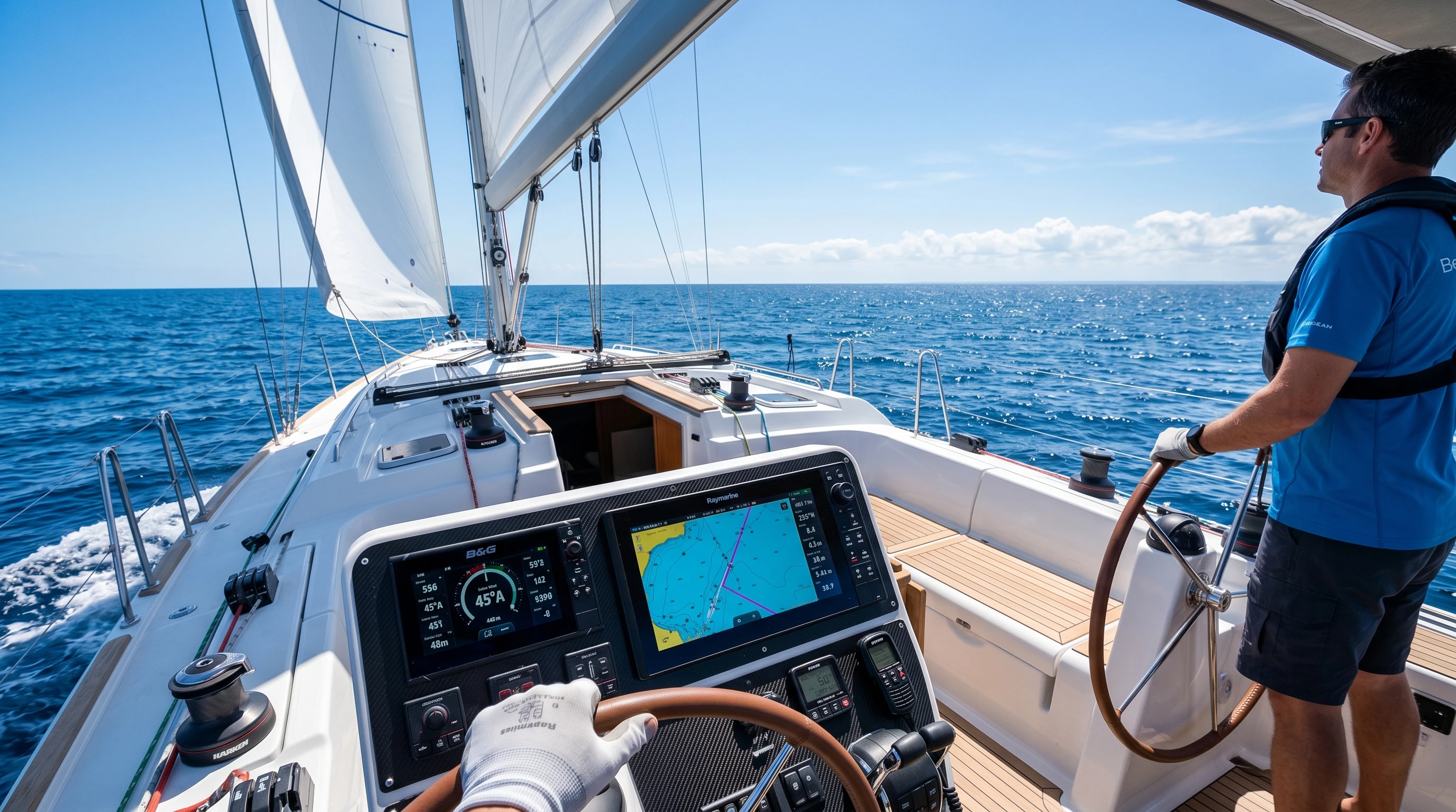
When I switch on my sailboat’s GPS system, it starts by “listening” for signals from at least four different GPS satellites. Each satellite sends out a constantly repeating signal with the exact time and its position in space. My GPS receiver measures how long each signal takes to arrive. By comparing these distances, the receiver performs calculations that determine my position on Earth.
My GPS device shows this info on a digital map, giving me a moving display of my location, sometimes down to a few meters of accuracy. Most marine GPS units also combine this info with digital nautical charts, which lets me see hazards, depth data, coastlines, and waypoints in a single view. The whole system doesn’t rely on cell service, which is a big plus when I’m offshore without a mobile signal.
- Position Fix: The basic job of GPS is to give me a “fix,” or my exact current position.
- Course Over Ground (COG): Shows my actual direction of travel, not just my heading.
- Speed Over Ground (SOG): Measures how fast I’m moving according to the satellites, not just through the water.
- Waypoint Navigation: Lets me mark, name, and return to specific locations on the map.
Getting Started with GPS Navigation for Sailing
Learning how to use GPS on a sailboat is pretty simple once I get used to a few key concepts. Here’s how I started out, and what I found most helpful:
- Choose a System: Decide whether I want a fixed-mount unit with a big display, a compact handheld, or a GPS app on my phone or tablet. Each has tradeoffs. Fixed units are reliable and weatherproof, but handhelds and mobile apps are portable and can serve as backups.
- Learn the Buttons and Menus: Every GPS unit is a bit different, so I always spend time getting familiar with menus, chart screens, and input methods before heading out.
- Set Waypoints: I mark places I want to visit, such as anchorages, marina entrances, or fishing spots. This makes returning much easier.
- Plan Routes: Most GPS systems allow me to build routes by connecting multiple waypoints, so I can see both the distance and bearing for each leg of my trip.
- Back Up My Data: I always write down waypoints and routes on paper, just to be safe in case electronics fail.
Top GPS Devices for Boats in 2026
The best GPS systems for sailboats in 2026 keep getting smarter, more compact, and easier to use. Here are a few features and models I find really useful for sailing:
- Touchscreen Chartplotters: Devices like the Garmin GPSMAP or Raymarine Axiom series combine GPS, sonar, radar, and electronic charts. Their bright touch displays make it easy to pinch, zoom, and swipe through maps, just like on a phone.
- Handheld Marine GPS: Portable units like the Garmin GPSMAP 86sc are waterproof, buoyant, and battery-powered. I use a handheld as a backup or for dinghy trips.
- Tablet and Smartphone GPS Apps: Apps like Navionics or iNavX use my phone’s built-in GPS and connect to downloadable chart databases. I keep a waterproof case handy for these.
- Integrated Systems: Some new GPS units link to autopilots, wind instruments, and AIS collision alert systems. This way, all my navigation data appears on a single display and supports automated navigation or route optimization.
Selecting one of the top GPS devices for boats depends on the size of my sailboat, my budget, and whether I want basic navigation or a full-featured system for cruising.
Key Features to Look for With GPS Technology for Sailing
Here’s what I usually look for when picking out a marine GPS for my boat:
- Chart Updates: I make sure the system allows easy updates, because charts change as channels move, new hazards are found, or new routes become popular.
- Battery Life and Power Options: Handheld GPS units run on rechargeable batteries, while fixed mount devices are wired to my boat’s battery system. I like to have spare batteries or a 12V charging cord for peace of mind.
- Waterproofing: My marine GPS takes a lot of spray, so a waterproof (or at least water-resistant) device is really important out on deck. The industry standard is often an IPX7 or IPX8 rating.
- Screen Brightness: Direct sunlight can make screens hard to read. I check for displays that stay clear and bright outdoors.
- Satellite Networks: Many new GPS devices also support GLONASS, Galileo, or Beidou satellites. This helps improve accuracy, especially in tricky spots like fjords, near tall buildings, or under trees.
If I’m sailing long distances or in areas without phone service, I lean toward standalone GPS systems or satellite-based communicators so I won’t lose navigation if the mobile network is down. When possible, I bring backup batteries and an extra device just in case.
How GPS Improves Sailing Safety
Safety is a big reason I never go sailing without GPS. Here are a few ways GPS has improved the safety of boaters everywhere:
- Avoiding Hazards: Digital charts on my GPS show underwater rocks, sandbars, and shallow spots. The system sounds an alarm if I stray too close to a hazard or run too close to land.
- Emergency Response: If I ever need help at sea, my GPS gives me an exact position to read off to the Coast Guard. Some devices even send my location by satellite to emergency contacts.
- Man Overboard Functions: With one button, I can instantly set a waypoint at my current position, making it much easier to circle back and get someone who fell overboard.
- Weather Routing: Advanced systems use GPS to track my boat’s progress and reroute for heavy weather or unfavorable tides.
- Predicting Arrival Times: By tracking my current course and speed, GPS devices give realistic estimates for when I’ll arrive at anchorages or harbors. This helps me avoid arriving in the dark or strong current.
Things to Think About When Choosing a GPS for Your Sailboat
Not all GPS units work the same way. I go through these points before making any buying decisions:
- Size and Installation: A small daysailer might do fine with a handheld, while larger cruising boats benefit from a bigger display mounted near the helm.
- Backup Navigation: Technology does not replace good seamanship. Even with the best GPS, I always carry paper charts and a compass in case power or electronics fail.
- Chart Coverage: I make sure to get charts for every region I plan to sail in. Some systems charge extra for additional map downloads or unlocks.
- Updates and Support: Manufacturers like Garmin, Raymarine, and Simrad provide regular updates and customer support if I hit any snags.
Battery and Power Tips
Running out of battery is a real concern, especially for handhelds. I bring spare power banks when using mobile GPS apps and always double-check wiring on my fixed gear. Solar panels or wind generators work well to keep batteries charged on longer trips.
Signal Loss or Weakness
Obstructed views, such as being under a canopy or sail, can weaken GPS signals. When this happens, I give the device a clear sky view. If accuracy drops, I switch to a backup GPS unit or use traditional navigation methods until the signal returns.
Keeping Charts Current
Waterways change frequently. I download the latest charts before every big trip and double-check for local notices to mariners or recently reported changes in navigation aids.
Practice is really important for comfort with marine GPS. I try navigating short legs or local passages with the tech before heading out on a big adventure. This way, I know what to do without second-guessing if conditions get tough.

Advanced GPS Navigation Tips for Sailors
Once I’m comfortable getting position fixes and following waypoints, I use advanced GPS features to improve efficiency on the water.
Layering Data: Many GPS devices let me overlay radar, wind instruments, fuel usage, or Automatic Identification System (AIS) targets on the same screen. This reduces confusion and gives me a clearer view of my situation.
Route Optimization: Advanced systems determine the best course based on wind conditions, currents, and waypoints. This can save fuel and time, especially on longer ocean passages.
Custom Alarms: I set alarms for route deviations, anchor drift, and proximity to navigation hazards. These reminders help avoid trouble if I get distracted or busy with other tasks on board.
Recording and Sharing Tracks: I use the track log feature to save my route. This means I can review my trip later, share the track with friends, or upload it to sailing forums to help others planning similar trips.
These tips help turn GPS into a full-time crewmember, supporting me whether I’m out for a few hours or crossing to a new country.
Where GPS Technology for Sailing Is Headed in 2026
2026 sailing GPS technology keeps changing, and a few trends stand out to me:
- Integration: Devices are more tightly connected with autopilots, radar, and boat monitoring systems, giving me centralized control from a single screen.
- Augmented Reality: Some new units have heads-up overlays that mark buoys, other boats, or hazards right on a live camera feed. This makes navigation feel even more intuitive.
- Cloud Synchronization: Sailors can now store and share routes, waypoints, and track logs in the cloud, syncing between the boat and home computers or mobile devices.
- Enhanced Satellite Accuracy: Support for new satellite systems and better antennas gives sailors more reliable position data, even close to shore or in packed marinas.
As technology continues to improve, marine GPS becomes smarter and easier to use. Staying up to date helps me sail more safely and confidently as new features are released.
Real World Examples: How I Use GPS on My Sailboat
I use GPS almost every time I’m on the water. A favorite example is running night passages along the coast, where visual markers disappear. My GPS keeps me in safe water and alerts me to any approaching buoys or shallow spots. When I’m racing, I use GPS to record tracks and analyze them later to spot mistakes or identify areas for improvement.
On an offshore crossing, GPS is essential. It helps me confirm that wind shifts or currents haven’t pushed me off course, even by a small amount. When I want to anchor, I mark my spot and set an alarm in case the boat drifts outside the safety circle. These simple habits make sailing less stressful and much more fun.
- Cruising: Planning multiday hops between islands by plotting all anchorages in advance.
- Fishing: Marking exact locations of good fishing spots so I can return easily.
- Day Sailing: Exploring unfamiliar bays and always finding my way back to the marina.
Frequently Asked Questions
Here are common questions I hear from sailors about using GPS on sailboats:
What should I do if my GPS fails?
I rely on paper charts, a compass, and my basic navigation skills. I also test backup GPS units or apps to make sure they’re charged and ready when needed.
Can I use a smartphone for GPS navigation?
Yes, but I always check if my phone’s GPS works without data service. I also use waterproof cases and bring backups because phones are not as rugged as marine devices.
Is GPS always accurate?
Under good conditions, GPS is usually precise to about 3-10 meters. Interference, poor satellite coverage, or signal reflections off metal can sometimes cause errors, so staying alert and double-checking positions is always smart.
GPS technology completely changed the way I sail, making trips safer and letting me relax and enjoy more time on the water. By understanding the basics, choosing the right device, and keeping up with new features, GPS navigation for sailing has become one of the most reliable and helpful tools I have on board.
Taking the time to practice and learn how GPS works on sailboats truly pays off. It boosts my sense of safety, reduces navigational stress, and opens the door to exploring new places, knowing I can almost always find my way home with confidence.
This article was created with AI assistance and reviewed by a human editor.
About The Author


Hello,
Thank you for this informative article about how GPS technology works on sailboats. As a delivery driver, I rely on GPS every day to help me find addresses, avoid traffic, and reach my destinations efficiently. Because of that, I found it very interesting to learn how GPS is also used for navigation on sailboats. Your explanation made the technology easy to understand and showed how important accurate positioning is, whether you’re on the road or on the water.
I think GPS has become an essential tool for transportation and safety. However, it’s always a good idea to know alternative navigation methods in case technology fails.
I have a question: Do experienced sailors still carry paper charts and compasses as backups, even when they have modern GPS equipment on board?
Hi, thanks for the kind words. Really glad the explanation made sense from a delivery driver’s perspective too. It’s a great point that GPS plays such a similar role on the road and on the water: getting you where you need to go accurately and efficiently.
To answer your question. Yes, absolutely. Most experienced sailors still carry paper charts and a compass as backups, and many sailing certifications and offshore safety standards actually require it. Electronics can fail from things like power loss, water damage, or even a lightning strike, so having a non-electronic way to navigate isn’t just good practice, it’s often considered essential seamanship.
Many sailors also use a “belt and suspenders” approach: a chartplotter as the primary tool, a handheld GPS as a backup power source, and paper charts plus a compass as the final fallback that needs no batteries at all. Plotting your position manually now and then also keeps those skills sharp, so they’re second nature if you ever really need them.
Thanks again for reading and for the thoughtful question!