Modern boating has definitely seen big changes over the past few years, and GPS navigation is at the heart of this popular trend. I vividly remember the first time I put a Garmin Marine GPS to use on my family’s fishing boat, the accuracy, speed, and safety boost were absolutely eye opening.
These days, whether I’m sailing open water solo or prepping for a quick weekend fishing trip, Garmin’s technology gives me the confidence and tools needed to be fully prepared. In this article, I’ll talk about what I’ve learned about Garmin’s latest marine GPS systems for boats, how they give a boost to navigation, what features you can expect, and how to pick the best option for your needs in 2026.
Why Upgrade to Garmin Marine GPS in 2026?
Digital navigation isn’t just convenient anymore, it’s now essential for safe, effective boating regardless of vessel size. Garmin GPS navigation for sailing is popular with casual boaters, expert anglers, seasoned sailors, and commercial operators. The newest 2026 models go a step further, bringing even more detail, faster refresh rates, and improved route guidance over both older units and smartphone apps. If you love new tech, you’ll appreciate these upgrades.
From personal experience, switching to a newer Garmin setup means less time stressing about my location or weather, and more time truly enjoying the water, finding prime fishing spots, social time onboard, or just breathing easy knowing I’m covered.
Another thing I love about Garmin’s latest GPS systems is how smoothly they work alongside other electronics like sonar, radar, and even autopilot functions. With everything neatly coordinated, I can run my boat’s key systems from just one screen, which really streamlines decision-making.
Core Advantages of Garmin GPS Navigation for Sailing and Fishing
When I size up marine electronics, I’m searching for three things: practicality, reliability, and genuine value. Here’s why Garmin’s 2026 lineup shines for both sailing and fishing enthusiasts:
- Pinpoint Accuracy: Real-time satellite tracking locks in my location, so I easily stick to my plotted course, even through foggy or unfamiliar waters.
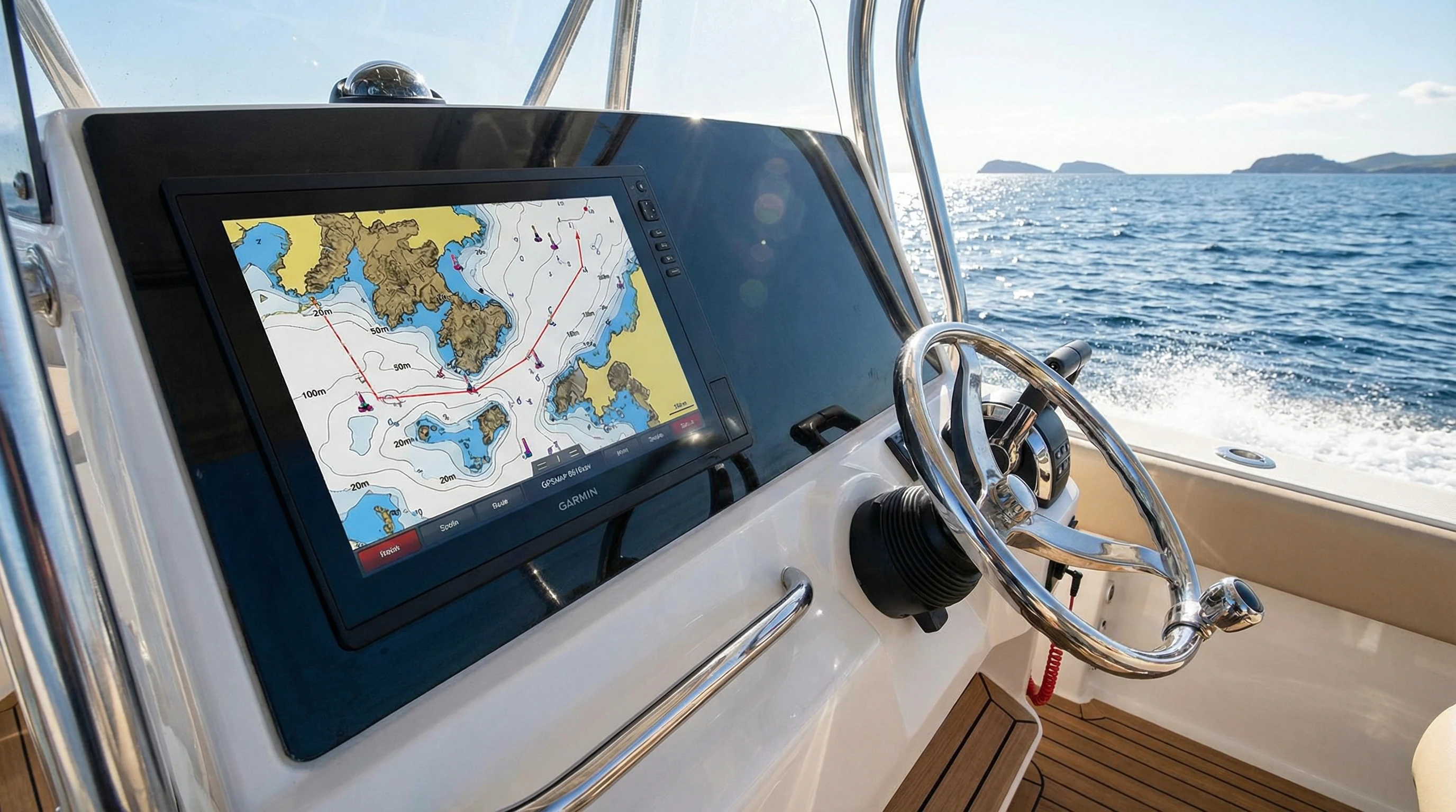
- Detailed Mapping: Built in BlueChart g3 and LakeVü g3 maps show everything from crucial navigation aids to tough to spot contour lines, marinas, and hidden underwater hazards. That level of detail gives peace of mind.
- Active Captain App Integration: With my smartphone or tablet, I update maps, get alerts, and tweak routes in just a few taps, no card swapping or IT headaches on the dock.
- Weather and Tides at a Glance: Integrated features give a quick look at local weather and tidal situations; that’s a game changer for catching the best fish or prepping for long sailing adventures.
Picking a unit that matches your boat’s size, your favorite waterways, and your main goals (relaxing, speed, offshore action) takes every trip to the next level.
Getting Started: Choosing Your Garmin Marine Navigation System
Whenever I look at buying a new marine GPS, these are the main points I weigh: installation, screen size, maps, system hookups, and ruggedness. Here’s a breakdown of what I prioritize before committing to a device:
- Display and Readability: A screen that’s bright, readable in sunlight, and easy to see in low light is a must. The 2026 models come with high def, anti-glare screens ranging from compact 6-inch versions (great for tiny boats) to big 16-inch and above units for larger setups.
- Installation Type: Portable designs work for smaller craft or rentals, but fixed-mount models are the go to for permanent installs, giving me confidence my gear isn’t going anywhere, even on choppy rides.
- Chart Coverage and Updates: Preloaded maps for my local waters make setup a breeze. Garmin’s Active Captain means I can wirelessly update charts, no more fussing with SD cards or wired connections.
- Networking and Expansion: I always opt for devices with NMEA 2000 or Ethernet support. This lets me mix in everything from engine data to autopilot, radar, and advanced sonar, so all my systems are working as one.
- Build Quality and Waterproofing: Gear on a boat takes a beating. Garmin GPS devices come with robust builds and water resistance that stands up to salt and freshwater adventures without missing a beat.
Factoring these criteria into my purchase decisions saves me time, money, and hassle, ensuring I get a navigation solution perfectly matched for my style of boating.
Essential Features I Rely On
The right features make all the difference on the water. Here are the Garmin marine GPS features I count on each outing:
- Touchscreen Interface: Smooth pinch to zoom and easy selection, even with wet hands or gloves, make navigation effortless.
- Quickdraw Contours: Quickly build custom, high res maps just by boating over new territory. This has helped me stumble upon unexpected fishing goldmines.
- Auto Guidance+: Lets the GPS map safe routes based on my boat’s draft and up to date chart info, easing the stress of coastal navigation or approaching tight inlets.
- Sonar Integration: Pairing with Garmin’s CHIRP or Livescope sonar for spot-on fish finding and targeting certain underwater features is a major advantage for serious anglers.
- WiFi and Bluetooth: Wireless capabilities allow me to link with phones, remote controls, or share data among crew members without complicated wiring.
- Waypoints and Tracks: Marking good fishing holes, favorite anchorages, or tricky channels helps me return to success stories easily every season.
These built in advantages create accuracy, ease, and enjoyment in both routine tasks and new adventures.
How Garmin GPS Gives Boating Safety a Boost
For me, safety has always been the biggest selling point of a strong marine GPS. Getting home before nightfall, avoiding unmarked rocks or sudden shallows, or finding obstacles in low visibility, these are places where a good GPS really shows its value.
- Depth and Obstruction Alerts: The GPS warns me right away about decreasing depth or underwater hazards, a feature that has saved a propeller more often than I’d like to admit.
- Automatic Man Overboard (MOB) Marking: One quick press and my Garmin logs the exact MOB spot, which is crucial for swift recovery in emergencies.
- Built-in AIS and Radar: Many 2026 models include AIS vessel tracking overlaid with radar feeds, showing traffic in real time and helping me steer clear of other boats, even in thick fog or busy channels.
- Emergency Call Functions: With VHF radio integration, one button sends distress calls and my current location to rescue teams if things go south.
Thanks to these features, I always feel that much safer out on the water, regardless of the crew or weather conditions.

Common Challenges and My Solutions
No new tech is completely plug and play, but I’ve learned a few ways to head off the common headaches when adding marine electronics:
Battery Drain
Big screens and linked-up gadgets need extra power. I always track my battery status, install a backup power source, and use power saving settings to keep everything working without interruptions.
Signal Interference
Other electronic gear or metal railings can sometimes mess with GPS signals. Putting units away from big metal parts and regularly checking connections makes a huge difference. Updates and maintenance are quick wins here.
Learning Curve
With so many features, it’s easy to feel overwhelmed at first. Garmin’s official online video guides and a little practice time at dockside get me up to speed fast. The menus are made to be self-explanatory once you spend a few minutes poking around.
Keeping Maps and Software Up to date
Chart data changes fast, so year round updates are a must. The Active Captain app lets me handle upgrades over WiFi, no laptop or SD card hassle before launching for a new season.
Advanced Tricks: Making the Most of Your Garmin GPS
Once you’re past the basics, these strategies give every trip an extra edge:
- Custom Map Layers: Add things like satellite imagery, hot fishing spots, and water temperature to your navigation screen. Mixing in local info with official charts is unbeatable for getting the most out of each ride.
- Split-Screen Modes: Seeing sonar, charts, radar, and engine info side by side means less button pushing and clearer decision making on the go.
- Community Data Sharing: With the Active Captain community, I share and get new tips about nearby hazards, recently added docks, or where the fish are biting. It puts local know how right at my fingertips.
- Wireless Networking: For multiple helm set ups or big groups, syncing all navigation screens wirelessly keeps everyone coordinated, that’s a big deal on bigger outings.
Using these extras has made each trip more productive, relaxing, and safe all around.
The Basics, Which Garmin System Is Right for You?
I started out with a small handheld Garmin GPS, portable, budgetfriendly, and handy as a back-up. As my boating style got more adventurous, I moved up to a fully integrated chartplotter combo. If you’re shopping, here’s what’s worked for me:
- Small Fishing Boats: Seven or nine inch Echomap units cover most local lakes, rivers, and nearby coastal waters, and they run happily on standard onboard power.
- Sailboats: Touchscreens or button control GPS units with specific sailing tools, tide info, and solid networking (like the GPSMAP lineup) are perfect for longer sails or regattas.
- Large Offshore Vessels: Multiple networked screens, radar overlays, and advanced engine data handling are a must for extra long trips or challenging ocean crossings.
Thinking about your main style of boating and the size of your vessel first simplifies shopping and steers you toward a system you’ll be happy with for years to come.
Frequently Asked Questions About Garmin Marine GPS 2026
Over the years, these questions always come up, here are my honest answers for newcomers and old salts alike:
Is Garmin GPS for fishing boats reliable in bad weather?
From what I’ve seen, Garmin models keep giving accurate positions and clear readings, even in stubborn fog or storms. While paper charts are good as a backup, I put my faith in the GPS’s alerts and depth sensors for real time safety guidance.
How often should I update my Garmin marine navigation maps?
Every start of the season and before traveling to new locations, I double check for available map and software updates. The wireless system Garmin uses makes this a fast, easy chore.
Can I use my Garmin marine GPS worldwide?
Newer units make it simple to add global maps through downloads or memory cards. Just confirm map coverage for your target region, and you’re good to go, no headaches or last minute obstacles.
A Few Final Thoughts
Picking the right Garmin marine GPS is an investment in both fun and safety. For me, the boost in accuracy, convenience, and peace of mind has made boating in 2026 better than ever. Reviewing your options carefully and matching your set-up to your favorite type of boating pays off for seasons to come. I trust Garmin not just for build quality but also for frequent software updates and ongoing support, which means my system improves even after the initial install. Safe boating rides on solid navigation. Garmin’s up to date solutions have kept me relaxed and confident on every trek, big or small.
Take a moment to think through your boating must haves, jot down what features matter most, and check out Garmin’s 2026 GPS options. They play a huge part in making time on the water smoother, safer, and a lot more fun for everyone.
About The Author


Great overview of Garmin’s latest marine GPS systems! I’ve been impressed by how well Garmin balances precision, usability, and integration with other onboard electronics. Features like Quickdraw Contours, Auto Guidance+, and the Active Captain app updates really make navigation easier and safer, whether on a small fishing boat or a large offshore vessel.
I’m curious—how do other boaters feel about Garmin’s sonar integration and split-screen modes? Have they noticeably improved your fishing or sailing experience? It seems like these features take the stress out of planning routes and finding hazards, which is huge for both recreational and professional users.
Thanks for the thoughtful feedback! I completely agree, Garmin has really dialed in that balance between precision and usability.
From what I’ve heard (and experienced), the sonar integration is where Garmin really shines, especially when paired with their CHIRP and LiveScope systems. The clarity and target separation can make a big difference when you’re trying to distinguish fish from structure. For anglers, that real-time feedback often translates directly into better decision making and, honestly, more productive days on the water.
The split screen modes are another underrated feature. Being able to run sonar, charts, radar, and engine data side by side reduces the need to toggle between pages, which is huge in busy or changing conditions. For sailors and offshore cruisers, having chartplotter data alongside AIS and radar improves situational awareness without overwhelming the display. It definitely helps reduce stress when navigating tight channels or unfamiliar waters.
I’ve also noticed that the integration with other onboard electronics, autopilot, trolling motors, and even Fusion audio creates a more seamless helm experience. When everything talks to each other smoothly, you spend less time managing systems and more time focused on the water.
That said, experiences can vary depending on boat setup and how much time someone invests in fine tuning settings. I’d love to hear if others have found particular sonar modes or display layouts that really transformed their time on the water.
I like how you focused on practical benefits that actually matter on the water, especially screen readability, reliable chart coverage, and how a Garmin marine GPS can integrate with sonar, radar, and autopilot for a cleaner setup. I have used a smaller chartplotter on inland lakes, and the biggest upgrade for me was being able to mark waypoints and tracks consistently, then come back season after season without second-guessing shallow areas or hidden structure. In my opinion, the real value in upgrading in 2026 is not just newer hardware, it is the safety layer from depth alerts and route guidance, plus the convenience of keeping maps updated without turning every trip into a tech project.
I really appreciate this perspective, you captured exactly what tends to matter once you’re actually out on the water.
It’s easy to get caught up in processor speed or screen size, but like you said, the real value shows up in practical things: readable displays in full sun, dependable chart coverage, and tight integration between systems. That ecosystem approach is where units like a Garmin marine GPS really stand out, especially when paired with sonar, radar, and autopilot for a cleaner helm and fewer compatibility headaches.
Your point about marking waypoints season after season is huge. That continuity builds confidence. Being able to return to productive structure or safely navigate around known hazards without second guessing depth contours is more than convenience, it’s situational awareness. Over time, those saved tracks and custom routes become a personalized safety map.
And I completely agree about 2026 upgrades being less about “new gadget energy” and more about the safety layer:
Depth and shallow water alertsSmart route guidanceCleaner integration with autopilotSeamless chart updates without manual SD card juggling
That last one is underrated. When updates are simple and automatic, people actually keep their charts current, which quietly improves safety more than any single hardware upgrade.
At the end of the day, the best marine electronics are the ones that reduce cognitive load. If you’re thinking less about the tech and more about conditions, traffic, and weather, that’s when you know the upgrade was worth it.