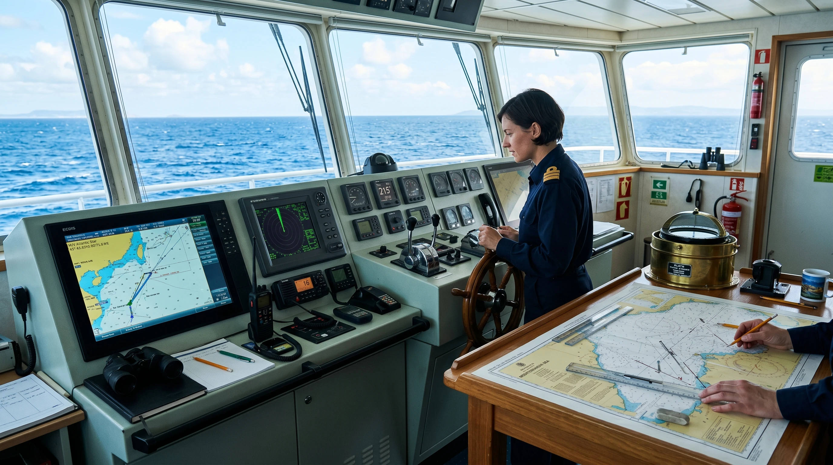
Step onto any modern bridge, and one of the first displays a watchkeeper glances at is the AIS. Understanding AIS maritime safety functions is no longer optional knowledge for deck cadets and junior officers; it is a core watchkeeping skill, examined in your oral assessments and relied upon every single day at sea. The Automatic Identification System has transformed the way ships see each other, the way coastal authorities monitor traffic, and the way rescue services locate people in distress. Yet AIS is also one of the most misused tools on the bridge, and knowing its limitations is just as important as knowing its strengths.In this guide, we break down how AIS works, what it does for collision avoidance and vessel tracking, where it fits within SOLAS and COLREGs, and the practical habits that will make you a safer, more confident officer of the watch.

What Is AIS and Why Every Watchkeeper Must Understand It
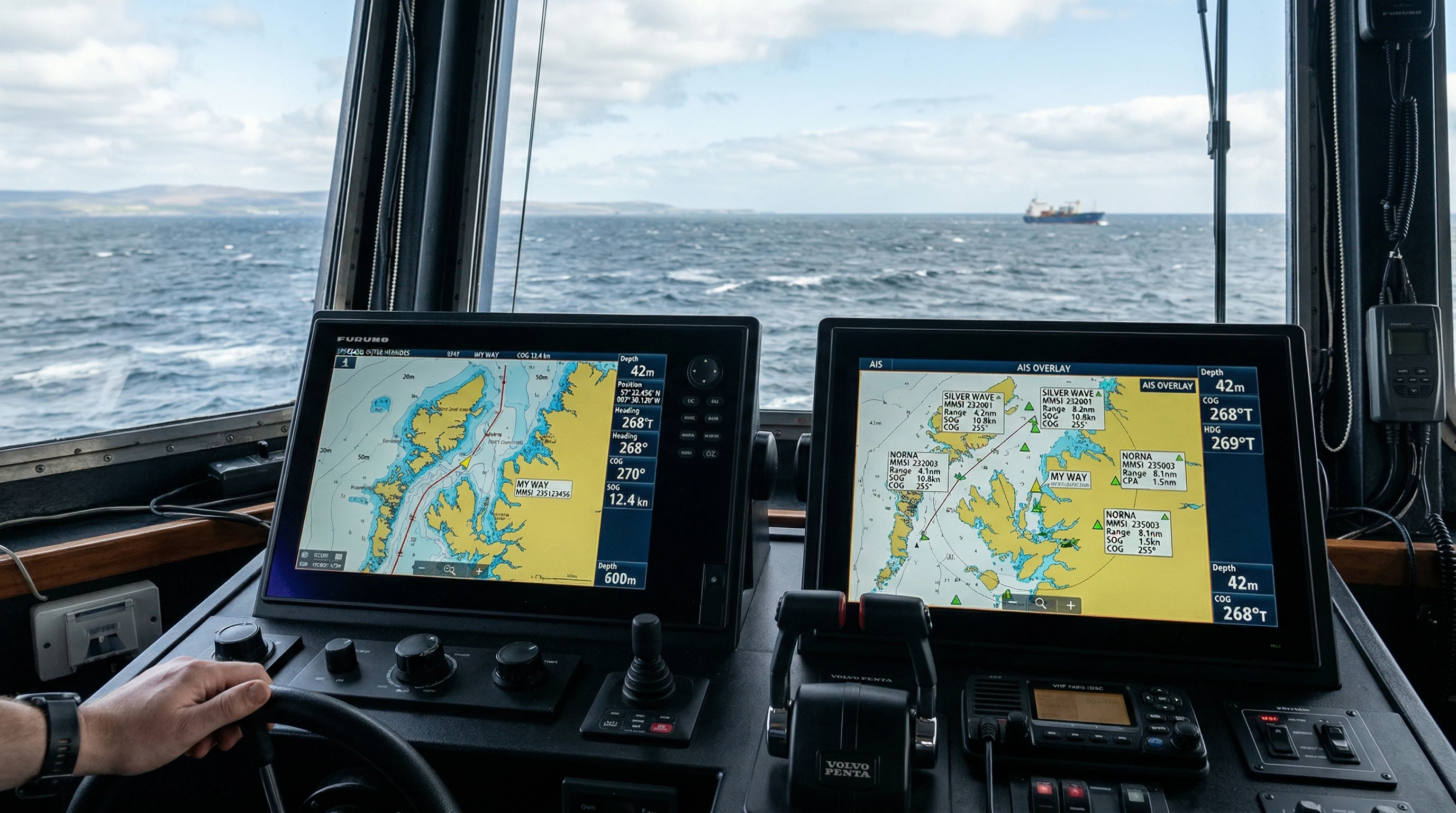
The Automatic Identification System (AIS) is a shipborne broadcast transponder system that automatically exchanges vessel information over dedicated VHF frequencies. Every few seconds, your ship transmits who she is, where she is, and where she is heading, and simultaneously receives the same information from every AIS-equipped vessel within VHF range, typically 20 to 30 nautical miles at sea.
For a junior officer, this means that a radar contact on a rainy night is no longer an anonymous blip. With AIS, that contact has a name, a call sign, a destination, a course, and a speed. You can identify the vessel before calling her on VHF, cross-check her intentions, and build situational awareness far earlier than radar alone would allow. That is the essence of AIS maritime safety: better information, earlier decisions, fewer surprises.
How AIS Works: Transponders and VHF Data Exchange
AIS operates on two dedicated marine VHF channels, AIS 1 (161.975 MHz) and AIS 2 (162.025 MHz), using a technique called Self-Organizing Time Division Multiple Access (SOTDMA). In simple terms, every transponder shares the radio channel by claiming short time slots, allowing thousands of vessels in busy waters like the Dover Strait or Singapore Strait to broadcast without blocking one another.
The information AIS transmits falls into three groups:
- Static Data
- MMSI number (Maritime Mobile Service Identity)
- Ship’s name and call sign
- IMO number
- Length, beam, and ship type
- Location of the position-fixing antenna on board
- Dynamic Data
- Position with accuracy indication (from GNSS)
- Course over ground (COG) and speed over ground (SOG)
- Heading and rate of turn
- Navigational status (underway using engine, at anchor, not under command, and so on)
- Voyage-Related Data
- Destination and ETA
- Draught
- Type of cargo (hazardous cargo category where applicable)
- Number of persons on board (on request)
Bridge tip: Static data is programmed once and rarely touched. Dynamic data updates automatically from the ship’s sensors. Voyage-related data must be updated manually by officers, and this is exactly where most AIS errors originate. Wrong draught, outdated destination, or “moored” status while doing 14 knots are all embarrassingly common.
Class A vs Class B AIS: Who Carries What
Not all AIS units are equal, and recognizing the difference matters when you interpret targets on your display.
| Feature | Class A | Class B |
| Typical users | SOLAS ships (cargo, tanker, passenger) | Fishing boats, yachts, and small craft |
| Transmit power | 12.5 W | 2 W (CS) / 5 W (SO) |
| Reporting rate (underway) | Every 2–10 seconds | Every 30 seconds or less often |
| Priority on the VHF data link | Higher | Lower |
| Rate of turn/nav status | Transmitted | Not transmitted |
The practical consequence: a Class B target updates more slowly, may appear later, and can even be dropped in very congested waters when the data link is saturated. Never assume a small craft’s AIS picture is as fresh or as reliable as that of a SOLAS vessel.
AIS and Collision Avoidance: A Powerful Complement to Radar
AIS collision-avoidance value comes from how it complements, not replaces, your radar and ARPA. The two systems have opposite strengths:
- Radar/ARPA detects anything that reflects energy: ships without AIS, small boats, buoys, ice, land. But it needs time to establish accurate target vectors, degrades in heavy rain and sea clutter, and can lose targets behind headlands.
- AIS gives you instant, accurate course and speed data (drawn from the target’s own GNSS), works beyond the radar horizon and around bends in rivers or behind islands, and identifies the target by name.
On an integrated bridge, AIS targets are overlaid on the radar display or ECDIS, and the system calculates CPA (Closest Point of Approach) and TCPA (Time to CPA) for each one. When an AIS target and a radar-tracked target correlate, you gain confidence in the picture. When they disagree, treat it as a warning to investigate.
AIS also transforms VHF communication. Calling “vessel on my port bow” invites confusion in heavy traffic; calling a ship by name and confirming her MMSI removes ambiguity, a small change that has prevented countless misunderstandings between bridges.
Critical Limitations: Why AIS Must Never Replace Lookout or Radar
Here is where cadets must pay closest attention, because over-reliance on AIS has contributed to real collisions and groundings.
COLREGs still rule the bridge
Rule 5 of the COLREGs requires a proper lookout by sight and hearing as well as by all available means. Rule 7 requires you to use all available means appropriate to determine the risk of collision and specifically warns against assumptions made on the basis of scanty information. AIS is one available means; it is never the sole means. IMO guidance makes it explicit that the officer of the watch should not rely on AIS alone for collision-avoidance decisions.
Not everyone transmits
- Small craft, fishing boats, and leisure vessels may carry no AIS at all.
- Warships and security-sensitive vessels may switch AIS off.
- A master may legitimately switch off AIS where its operation might compromise the ship’s security, such as in piracy high-risk areas, with the decision recorded in the logbook.
The data is only as good as the input
AIS position and speed come from the target ship’s own sensors. A faulty GNSS receiver, a gyro error, or an officer who never updated the navigational status will broadcast wrong information to everyone around. You have all seen the “anchored” vessel steaming past at full sea speed. Verify AIS data against radar and visual bearings before acting on it.
Remember: AIS tells you what a ship says she is doing. Radar and your own eyes tell you what she is actually doing. When the two disagree, believe the radar and the window.
SOLAS Chapter V: AIS Carriage Requirements
Under SOLAS Chapter V, Regulation 19, AIS is mandatory for:
- All ships of 300 gross tonnage and upwards engaged on international voyages;
- Cargo ships of 500 gross tonnage and upwards not engaged on international voyages;
- All passenger ships, irrespective of size.
The regulation also requires that AIS be in operation at all times, except where international agreements, rules, or standards provide for the protection of navigational information. Flag states and port state control inspectors check both the equipment and the accuracy of its programmed data, so sloppy AIS entries can attract deficiencies during inspections.
Operational guidance for watchkeepers is set out in IMO Resolution A.1106(29), the revised guidelines for the onboard operational use of shipborne AIS — recommended reading before your first solo watch.
Beyond Collision Avoidance: SAR, VTS, and AIS-SART
Search and Rescue operations
In a distress situation, AIS provides rescue coordination centers and nearby vessels with an immediate, continuously updated picture of who is in the area and best placed to assist. Aircraft equipped with AIS receivers can identify surface vessels and coordinate directly with them.
AIS-SART: a lifesaving transmitter
The AIS Search and Rescue Transmitter, carried in survival craft, transmits a standardized distress message with GNSS position once activated. On any AIS display within range, it appears as a distinctive SART symbol, guiding rescuers straight to the liferaft. Unlike the older radar SART, it does not depend on a rescuer’s radar beam sweeping across it — it broadcasts continuously.
Vessel Traffic Services
Shore-based VTS centers rely heavily on AIS for vessel tracking, traffic organization, and reporting. In many VTS areas, AIS reduces or replaces lengthy VHF position reports, cutting radio congestion and freeing the watchkeeper’s attention for navigation. AIS data also supports coastal state monitoring, port logistics, and incident investigation.
Practical AIS Tips for Cadets and Junior Officers
Good AIS discipline is a mark of a professional watchkeeper. Build these habits early:
- Check voyage data at the start of every passage. Confirm that destination, ETA, draught, and navigational status are correct, and update the status at every change (anchoring, pilotage, restricted maneuverability).
- Verify before you trust. Cross-check AIS targets against radar tracking and visual bearings. Correlate, don’t assume.
- Use AIS for identification, radar for decision. Base your collision avoidance action on systematic observation, compass bearings, and ARPA data, with AIS enriching the picture.
- Mind the Class B traffic. Slow update rates mean a small craft’s displayed vector may already be stale in close quarters.
- Never maneuver based on AIS text messages. Negotiating passing arrangements by AIS messaging is poor practice; if communication is needed, use VHF and keep it consistent with COLREGs.
- Report defects immediately. A silent or faulty AIS makes your ship partly invisible to others and non-compliant with SOLAS.
- Log what matters. If AIS is switched off for security reasons, record it and switch it back on as soon as the threat has passed.
FAQ: AIS Maritime Safety Questions Answered
What is the main purpose of AIS on ships?
The primary purpose of AIS is to enhance the safety of navigation by enabling the automatic exchange of identification, position, course, and speed data between vessels and shore stations, improving situational awareness, collision avoidance, and vessel traffic management.
Can AIS be used alone for collision avoidance?
No. AIS is an aid that supports collision avoidance but must never be the sole basis for action. COLREGs Rules 5 and 7 require a proper lookout and the use of all available means, including radar plotting and visual bearings, to assess the risk of collision.
What is the range of AIS at sea?
AIS uses VHF radio, so range depends on antenna height and propagation; typically, 20–30 nautical miles ship-to-ship and farther to elevated shore stations. Satellite AIS extends global tracking coverage, though with less frequent position updates.
Which ships must carry AIS under SOLAS?
SOLAS Chapter V Regulation 19 mandates AIS for all ships of 300 GT and upwards on international voyages, cargo ships of 500 GT and upwards on domestic voyages, and all passenger ships regardless of size.
What is the difference between AIS and radar?
Radar detects objects by reflected radio energy and operates independently of the target’s equipment, whereas AIS relies on the target transmitting its own data. Radar sees non-AIS targets; AIS sees around obstructions and identifies ships by name. Used together, they provide a far stronger navigational picture than either alone.
Conclusion: AIS Is a Tool, You Are the Safeguard
AIS maritime safety benefits are beyond dispute: earlier target identification, richer collision avoidance data, streamlined VTS reporting, and faster search and rescue response. For a new officer, mastering AIS means knowing its data inside out, keeping your own ship’s transmission accurate, and, above all, respecting its limits.
Treat AIS as one voice in the conversation on your bridge, alongside radar, ECDIS, visual lookout, and sound judgment shaped by STCW watchkeeping standards. The equipment enhances safety; the watchkeeper delivers it. Learn the system now, question its data always, and you will carry a habit that protects your ship, your crew, and your career for decades at sea.
This article was created with AI assistance and reviewed by a human editor.
About The Author