Modern navigation methods for sailboats have truly switched up how I plan and enjoy my time at sea. Comparing digital navigation tools with traditional navigation techniques on sailboats helps me identify unique strengths and potential pitfalls in both. Knowing how to mix old-school tricks and fresh tech gives me confidence and flexibility for any adventure.
Overview: Why Navigation Still Matters for Sailboats
Navigation gives me the info I need to get safely from one spot to another. Even though tech has changed the sailing game, knowing both traditional and modern navigation methods lets me make better decisions on the water. Every sailor relies on being able to find their way, whether staying close to shore or heading offshore for longer rides. Following a guide to sailboat navigation techniques keeps me ready for surprise conditions, tech breakdowns, and changing rules.
The story of sailing navigation goes back thousands of years. Ancient sailors used stars, the sun, and natural markers to cross vast oceans. Today, comparing sailing GPS with traditional methods shows just how far we’ve traveled—and why classic skills still matter. Both worlds have their own gear, language, and safety habits. By learning about traditional versus modern sailing navigation, I unlock more options and get real resilience as a sailor.
Traditional Sailboat Navigation Techniques Explained
Traditional navigation relies on skills and tools that worked way before electronics entered the picture. These are routines I use when I want to get a sense of my surroundings and feel connected to the adventure itself.
- Celestial Navigation: Using the positions of the sun, moon, stars, and planets to figure out my location when land’s nowhere in sight. Tools include a sextant, a nautical almanac, and an accurate watch.
- Dead Reckoning: Guessing my position based on speed, course, heading, and time since my last known location. I use a compass, a speed log, charts, and simple notes.
- Piloting: Finding my way by spotting landmarks like buoys, lighthouses, and land features and comparing them to paper charts. Bearings and distances get measured with a handbearing compass and dividers.
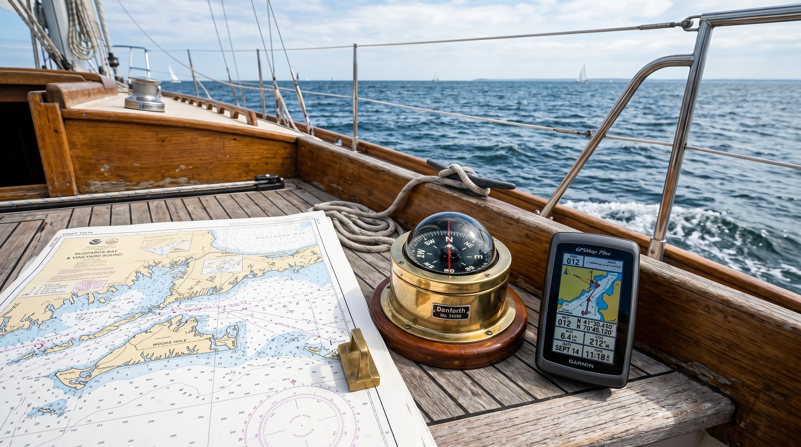
- Paper Charts and Plotting Tools: I use charts, parallel rulers, and dividers to draw out courses and check distances. Reading paper charts remains essential every time.
- Leadlines and Soundings: Dropping a weighted rope (leadline) lets me measure water depth and spot hazards below—handy in shallow or unfamiliar harbors.
Advantages of Traditional Methods
- I can sail without batteries, power, or signals, which makes me independent if tech fails.
- Learning old-school navigation skills steps up my seamanship, awareness, and decision-making overall.
- These techniques are widely accepted and form the basis of most maritime rules and training systems.
Challenges of Traditional Methods
- Staying sharp takes steady practice. If I skip this, mistakes crop up much more easily.
- Manual accuracy depends on my attention and math, making human error more likely.
- Bad weather, night, or fog make visual tools tougher to use.
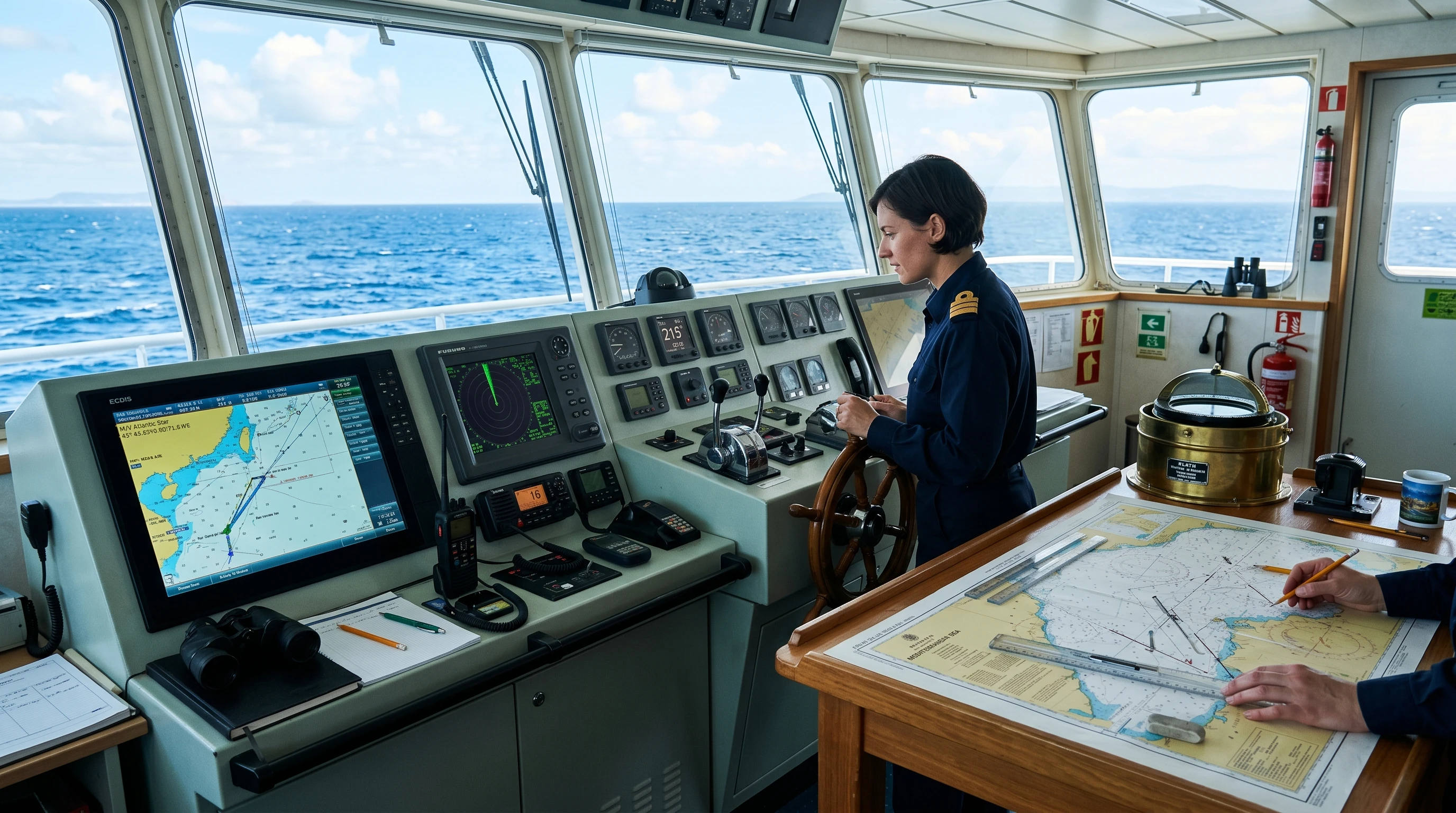
How Modern Navigation Methods for Sailboats Work
Modern navigation tech for sailboats uses electronics, quick calculations, and instant communication. These updates speed things up and unlock features few people imagined just years ago.
- GPS (Global Positioning System): Satellite networks give my real-time position, speed, and course. Most GPS gadgets are accurate within meters, and I can use handheld units, chartplotters, or even phone apps.
- Electronic Charts (ENCs): Digital charts on a screen show real-time updates, tide and current info, and can warn about new hazards. I can zoom to see more or less detail instantly compared to paper charts.
- AIS (Automatic Identification System): This system shares info about my boat and surrounding vessels. It’s a huge help to spot and avoid collisions in busy waters or when visibility drops.
- Radar: Modern radar lets me find land, ships, and even big buoys in darkness or fog. This gives serious peace of mind in tough conditions.
- Autopilots and Integrated Systems: Autopilots use sensors and chart data to keep the boat on track, letting me focus on other jobs. Not only that, but modern dashboards can combine chart data, weather, and traffic updates into a single view for me.
Advantages of Modern Methods
- These systems make navigation faster and eliminate classic mistakes caused by fatigue or distractions.
- I get fast alerts for hazards, route changes, or sudden weather switch-ups.
- Modern chartplotters layer AIS and radar for a super detailed look at my surroundings.
- Sharing my route or checking in becomes simple with connected gadgets.
Challenges of Modern Methods
- All this gear needs power and can stop working without warning. Losing GPS or a battery means instant info loss.
- Software, updates, and repairs can be expensive or require specialized support that I don’t always have offshore.
- Screen clutter, bugs, or signal loss could leave me turned around or confused.

Sailing GPS vs Traditional Methods: How They Compare
Comparing traditional stuff with modern sailing navigation reveals clear trade-offs in dependability, accuracy, cost, and comfort. In my experience, blending both keeps me safer and more adaptable than picking just one toolbox.
- Accuracy: GPS is usually more precise and much faster for real-time use, but traditional tricks save the day if signals go down or get blocked.
- Reliability: Paper and manual skills never count on power or connections. Electronic systems could glitch or fail without warning if I don’t have backup.
- Learning Curve: Old-school methods require more initial study, but they give me confidence to solve problems on the fly. Digital systems make things easier, but work best if I know the basics underneath.
- Cost and Maintenance: Manual tools are affordable and last for ages, while electronic tools can cost more upfront and require regular updates.
- Adaptability: Mixing both means I can switch things up if conditions, routes, or gear change unexpectedly.
How to Navigate Sailboats Without GPS
Knowing what to do if the GPS quits is at the heart of seamanship. Here’s how I get things done with classic navigation, plus skills worth keeping fresh:
- Get Comfortable Reading Charts: I always have current paper charts on board and plot my location by hand, even when using GPS.
- Trust the Compass: Magnetic compasses stay my guide for setting and holding direction, especially in rough or open water.
- Track Time and Speed: I use a log, mechanical, electronic, or drift a simple rope, to estimate how far I’ve traveled since my last fix.
- Mark Bearings with a Handbearing Compass: Regularly checking bearings on visible marks (buoys, buildings, or stars) helps me double-check my spot on the chart.
- Estimate With Dead Reckoning: I figure out my position by blending heading, speed, and time until I can visually confirm or switch to celestial navigation.
- Use Celestial Cues: For extended trips, a sextant and navigation tables help me double-check latitude and longitude if all else fails.
Practicing these steps keeps my skills sharp and my confidence high, no matter what gadgets are on deck.
Things to Think About Before Choosing Navigation Tools
Picking out my mix of navigation gear takes some practical thought, past grabbing something off the shelf. Here’s what I keep in mind:
- Power Supply: I bring backup batteries and charging options for every trip. Solar chargers or portable power banks make sure my GPS and gadgets stay online when needed.
- Chart Updates: I check my charts, digital and paper, to make sure they’re current. Hazards and aids to navigation change often, so staying up to date pays off.
- Training and Drills: I spend time on and off the water learning new software, updating gear, and practicing manual skills.
- Redundancy: A spare GPS, backup compass, and extra batteries are easy insurance for equipment failure or accidental damage.
- Weather and Environment: Heavy weather can throw off GPS and make visuals tricky, so I always map out backup plans or safe holding spots.
Dealing With Navigation Failures
If a system breaks down at sea, I use a simple plan:
- Switch over to plotting on paper charts by hand.
- Slow down and keep a close lookout all around.
- Use the radio to ask nearby boats or shore stations for any updates, if possible.
- Stick with well-known routes and monitor depth with a leadline or sounder.
Advanced Tips for Combining Traditional and Modern Navigation
Once the basics are down, mixing up navigation styles brings out the best from every approach. Here’s what I do to get the most from both worlds:
- Maintain a Manual Plot Always: Even during short trips, I log my position hourly on paper. It makes a fast backup if electronics die suddenly.
- Overlay Radar and AIS: Using radar and AIS on the electronics alongside my paper chart keeps me fully aware in fog, night, or whenever traffic gets thick.
- Get Gear Ready Before I Go: I check the software and charts for updates before I leave the dock, not after.
- Mix Old and New in Training: Celestial fixes and handbearing practice during downtime sharpens my brain, and my crew’s too. I pull everyone into drills so the whole team is ready for anything.
Pairing up reliable manual skills with the speed and detail of next-level cool tech keeps my options open. It’s bailed me out more than once when gear glitches pop up without warning.
Real-World Uses: Navigation Choices During Sailboat Voyages
Every trip brings its own challenges and risks. Here’s how I mix my navigation tools on real passages:
- Coastal Day Sails: I mostly use electronic chartplotters and GPS for ease, but always keep a paper chart for eye tracking.
- Offshore Passages: I rely on GPS, AIS, and radar, but I make sure to plot a daily fix using celestial sightings and keep backup tools always within reach.
- Entering Harbors at Night: Radar and AIS pick out buoys and boats I can’t see. I double-check what I see with both my paper chart and what’s in front of me.
- Fog or Bad Weather: I lean on radar and chartplotters, but fall back on dead reckoning, handbearing, and depth soundings if signals fade or screens freeze.
Frequently Asked Questions on Sailboat Navigation Techniques
Here are some common questions from chats with other sailors:
Question: How accurate are modern GPS systems on sailboats?
Answer: Most GPS receivers keep me within about 3 meters of accuracy in open water. With frequent updates, it’s reliable, but clouds, interference, or broken equipment may cause issues.
Question: Is it still necessary to carry paper charts?
Answer: I always bring paper charts. They’re the best backup for gear problems or when I need a big-picture view at a glance. Some anchorages make more sense when I look at both.
Question: Can I navigate a sailboat without GPS?
Answer: Yes, and I’ve done it plenty with dead reckoning, piloting, and celestial navigation. Regular practice is the secret to staying sharp when tech isn’t around.
Question: What’s the biggest benefit of using AIS?
Answer: AIS gives me real-time info on nearby boats, shrinking collision risks. It’s a lifesaver on busy shipping lanes, especially at night or in thick fog.
The Future of Navigation for Sailors
Sailing navigation is advancing as technology keeps evolving. Tools like AI route planning, real-time weather, crowd-sourced depth maps, global satellite tracking, and augmented reality overlays are close to becoming the new normal. They make trips safer and simpler, solo or with a group, even when conditions get tricky. Still, I plan to keep classic skills fresh and my backups ready. The sailors I admire most blend new tools and old-fashioned seamanship, so they’re ready for anything, anytime, no matter what curveballs the ocean throws their way.
This article was created with AI assistance and reviewed by a human editor.
About The Author