Integrating AIS (Automatic Identification System) with marine GPS technology can make navigation much safer and more efficient for boaters and commercial vessel operators alike.
I’ve gone through the process myself on my own boat and have seen firsthand how bringing these two systems together makes route planning, collision avoidance, and daily cruising much more comfortable. If you’re considering marine GPS integration with AIS or want to know what’s involved in combining these maritime technologies, my experience and tips can help guide you through the process.
The Value of Marine GPS and AIS Integration
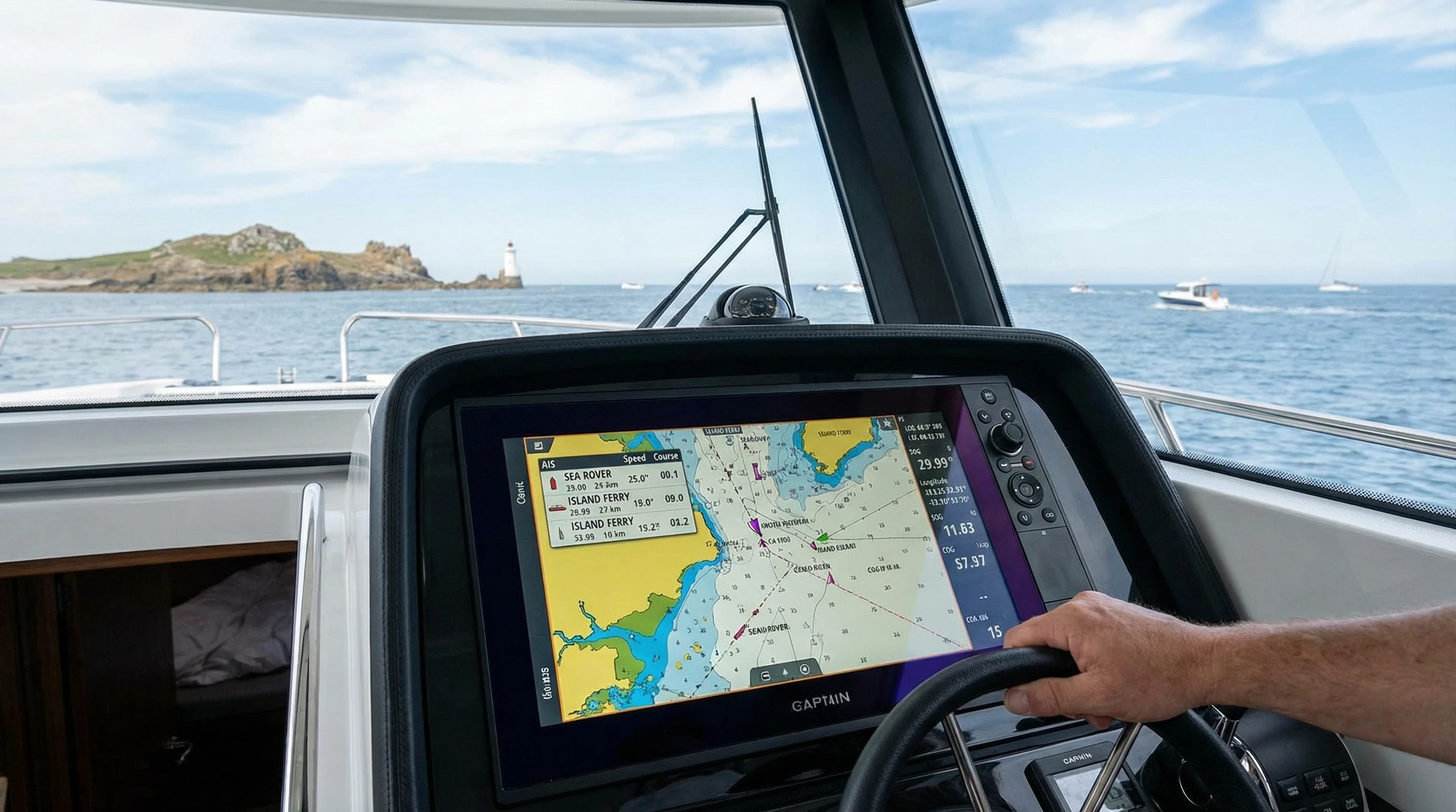
Marine GPS integration with AIS is changing how navigation gets done at sea. GPS tells you exactly where you are, while AIS broadcasts your vessel’s identity, speed, course, and more to other boats nearby, and lets you see them in return. Integrating AIS and GPS technology allows you to plot both your position and the positions of AIS-equipped vessels on a single screen, in real time. For me, this means staying aware of everything around me with less mental math and fewer devices at the helm.
This technology benefits everyone from solo sailors to cargo ship captains. The marine industry expects AIS technology adoption to keep rising, with more boats, both commercial and recreational, installing systems every year. This trend has been helped by regulatory changes, falling equipment costs, and the drive for safer navigation.
How Marine GPS and AIS Work Together
Understanding the basics of integrating AIS and GPS is helpful before you get started. AIS uses radio transponders to send and receive vessel information, while GPS delivers highly accurate position and time data using satellites. When you connect these systems through your onboard display or chartplotter, the combined information gives you a live chart view showing your location and every AIS-enabled vessel within range. This setup makes traffic patterns and collision risks much more obvious.
Typical marine setups may use a single display for GPS and AIS data, or connect to a NMEA 2000 network, which is a standardized communications bus for marine electronics. This allows even older boats with different brands of devices to share and show all the same information.
- AIS Class A vs. Class B: Class A units are required on larger commercial vessels and broadcast at higher power, showing details like destination and cargo. Class B units, used mainly by recreational boaters, broadcast at lower power and update less frequently. Both benefit from GPS integration.
- NMEA Standards: These standards (NMEA 0183 and NMEA 2000) make it easy to connect devices from different manufacturers, streamlining the integration process.
- Chartplotter Displays: Modern displays support overlays, showing AIS contacts alongside your route and other navigation information.
First Steps: Planning Your AIS and GPS Integration
I found that starting with a clear plan is really important when bringing marine GPS and AIS units together. Some systems come ready to connect, while others need extra cables, adapters, or software updates. Here’s my checklist when I started integrating AIS and GPS technology on my own boat:
- Inventory Your Equipment: List what you already have (GPS receiver, chartplotter, VHF/AIS unit) and what you’ll need.
- Check Network Compatibility: Look for NMEA 0183 or 2000 support. Most modern electronics work on NMEA 2000, but adapters can help join older gear.
- Research Display Options: Decide if you want AIS contacts on your chartplotter, a separate screen, or sent to your phone or tablet as well.
- Review Power Requirements: Some AIS systems draw more power than expected, so check that your electrical system is up to the task before installation.
Careful planning makes the rest of the process much smoother. By checking connections and compatibility ahead of time, I avoided a lot of frustrating rewiring or returns.
Common Challenges During Marine GPS AIS Integration
Bringing AIS and GPS together comes with a few technical hurdles. Based on my experience, here are some typical problems and straightforward ways to handle them:
- Data Compatibility: Not every AIS and GPS unit speaks the same language. Issues with NMEA sentence formats can lead to missing or incomplete data on your chartplotter. Software updates or protocol converters usually fix this.
- Power Supply Noise: Some boats have electrical systems that interfere with radio signals, leading to unreliable AIS reception. Using ferrite cores, shielded cables, and good connections helps.
- Poor Antenna Placement: Installing the GPS or AIS antenna too close to metal or other electronics can affect reception. Placing antennas high and free of obstructions improves range and signal clarity.
- Firmware or Software Confusion: Incompatible firmware versions on chartplotters, AIS units, or GPS receivers can stop data from sharing properly. Checking for updates before connecting everything saves time.
Each of these problems has a solution, and most can be avoided by reading manufacturer guides and planning out where devices and cables will go before starting the install.
Best Practices for Reliable Marine GPS AIS Integration
After talking with fellow boaters and marine electronics installers, I’ve collected a few best practices for AIS integration. These steps help avoid frustration and keep data accurate and up-to-date:
- Double-Check Your Connections: Loose or corroded cables cause unreliable data feeds. Marine grade wiring, sealed connectors, and periodic inspections prevent most issues.
- Isolate the Power Supply: Running sensitive electronics from their own circuit (with proper fusing) helps keep voltage steady and reduces electrical noise.
- Use a Dedicated AIS Antenna: Sharing an antenna between VHF and AIS using a splitter sometimes leads to missed signals. A dedicated antenna (well-placed and vertical) increases reliability.
- Test in Port First: Before going out, test your integrated system at the dock. Watch for all expected vessels on screen and confirm that other boats see your AIS broadcast.
- Keep Software Updated: Manufacturers often release updates that improve data compatibility and fix bugs. Updating chartplotters, AIS units, and GPS receivers is a regular part of my annual maintenance.
These practical steps keep marine GPS integration working dependably, so you’re not troubleshooting when you should be focusing on navigation. Also, keeping a clear record of changes and regular backup of device settings ensures that if something goes wrong, restoring your setup is much simpler.
AIS Data Accuracy Improvements with GPS Integration
A major benefit I’ve noticed after integrating AIS and GPS is the improvement in data accuracy. With your GPS position feeding directly into the AIS transponder, your location, speed, and heading are all up to date. This real time link means your vessel’s broadcast is more precise, which greatly reduces the chance of confusion or close encounters at sea.
Some advantages I’ve enjoyed from this setup include:
- Clearer and more detailed target tracks on the chart display, so it’s easy to understand another vessel’s movements
- Smoother data handoff between devices, removing lag between your actual position and the one shown on screen
- Better information flow for traffic services and other vessels using AIS to monitor marine safety
When using older or nonintegrated setups in the past, I noticed jumpy or delayed AIS targets, which made close situations stressful. Now, tracking vessels and planning maneuvers is much more straightforward. Reliable integration makes long passages and busy waterways safer for everyone onboard.
Recent Trends in Marine AIS Technology
Marine AIS technology trends have made integration easier and more accessible in the past few years. Some of the changes I’ve followed include:
- Wide adoption of NMEA 2000 networks, allowing plug-and-play connectivity for most new equipment
- Smaller and more energy efficient AIS transponders designed for even small boats or tenders
- Cloud connected and WiFi-enabled displays allowing AIS and GPS data to sync with smartphones, tablets, or remote monitors
- An expanding ecosystem means boaters have more choices for integration at a variety of price points. Even fishing kayaks and runabouts now benefit from AIS equipped compact VHF radios and simple GPS plotters. I’ve enjoyed seeing how many more people can access these safety improvements compared to just a few years ago.
Lessons I’ve Learned Integrating AIS and GPS Onboard
After installing and using integrated AIS and GPS systems, there are a few key lessons I want to share:
- Patience Matters: Integration takes patience, especially if you’re new to marine electronics. Taking your time to read manuals, watch how-to videos, and check online forums helps you avoid mistakes.
- Keep Notes: I found it really helpful to write down how I connected devices, what settings I changed, and where I ran cables. This made it much easier to track down connection or data issues later.
- Test in Real Conditions: Testing everything at the dock is good, but I always make a point to watch how the system behaves in open water and in busy shipping lanes. Sometimes small issues only pop up when multiple boats are transmitting nearby or during unusual conditions.
- Ask for Help if Needed: Marine electronics installers and knowledgeable boatyard staff are usually happy to share advice or help troubleshoot. Online communities like Panbo and Cruisers Forum are also great sources of information.
These lessons keep the project moving forward and have helped me get the most value from the technology over time. Sharing your own findings with other boaters can help them get set up even faster.
Marine GPS AIS Integration for Real-World Situations
I’ve put integrated AIS and GPS technology to the test in a wide range of boating situations. Here are a few examples of how combining these tools makes life easier and safer on the water:
- Night Passages: In the dark, seeing nearby vessel information overlaid directly on my GPS chart makes it much less stressful to identify moving ships and plan a safe path.
- Busy Ports: When entering harbors with lots of vessel traffic, integrated AIS lets me spot small boats or quickly changing targets that might otherwise be tough to see visually.
- Fishing Operations: AIS integration helps keep track of other fishing boats in the fleet, making coordination and collision avoidance simpler, especially when everyone is spread out.
- Offshore Cruising: On longer offshore legs, seeing both commercial and recreational traffic clearly plotted against my route gives me more confidence to rest during a watch or in autopilot mode.
In each of these cases, integrated GPS and AIS help you make better decisions, increase safety margins, and reduce stress, whether you’re solo or have a large crew. You’ll quickly appreciate how information presented on a single screen makes maintaining awareness second nature, especially in tough conditions.
Frequently Asked Questions About Marine GPS AIS Integration
Here are answers to common questions I’ve received from fellow boaters considering this upgrade:
Question: What’s involved in connecting AIS to my GPS?
Answer: Most modern AIS and GPS units use NMEA 2000 or 0183 wiring. Plugging in a backbone cable (for NMEA 2000) or connecting TX/RX wires (for NMEA 0183) and configuring the display menu settings usually does the trick. Confirm that both devices see each other before heading out.
Question: Do I need a professional installer?
Answer: If you’re comfortable with simple wiring and following step-by-step manuals, much of the installation can be done yourself, but a professional can help with complex or larger systems. They can also offer advice on antenna placement to maximize performance.
Question: Can I use my old GPS unit with a new AIS transponder?
Answer: It depends on compatibility. Check for supported NMEA protocols on both devices. Sometimes a protocol converter or software update is all you need.
Question: What if other boats can’t see my AIS signal?
Answer: Check antenna connections, power supply, and all wiring for damage or corrosion. Updating firmware and checking splitters or multiplexers often helps. If you still have issues, a marine electronics technician can run signal tests to diagnose the problem.
My Key Takeaways and Recommendations
Marine GPS integration with AIS can totally boost your boating experience. With careful planning, attention to compatibility, and periodic checks on hardware and software, the benefits really add up. I’d recommend this upgrade to anyone who wants more peace of mind on the water, from day cruisers and weekend sailors to commercial crews. Safe and confident navigation depends on good awareness, and AIS and GPS integration provides that.
From improved traffic awareness to easier route planning, I rely on my integrated system every time I’m at the helm. Getting the setup right paid off, and I hope sharing my lessons makes your own integration project smoother.
If you have questions or want more detailed advice, reach out to marine electronics communities or talk to equipment dealers. The boating world has many knowledgeable people willing to help, and learning from their experience just speeds up your own adventure.
About The Author


