When I first stepped onto a boat as a new sailor, marine navigation tools 2026 were already changing how people learned to find their way on the water. The compass and nautical charts remain at the core of marine navigation, but technological tools built around them have significantly improved how sailors, fishermen, and ship crews navigate at sea. In this article, I’m sharing everything you need to know about the practical uses of compasses and charts in modern marine navigation, along with how you can make smart choices from the evolving set of navigation technology.
The Basics: Why Compasses and Charts Still Matter
Sailors have relied on compasses and charts for hundreds of years. The magnetic compass is a simple tool that shows north by using the Earth’s magnetic field. Nautical charts are maps designed specifically for use at sea. They show water depths, land features, buoys, hazards, and routes. Even with satellites, GPS, and electronic devices, the compass and proper charts remain really important for safety and confidence at sea.
When technology fails or you lose power, paper charts and a compass provide a backup. As someone who loves spending time on the water, I know how quickly the weather can change and how quickly technology can stop working. Knowing how to read a chart and use a compass gives me a lot more confidence when things get tricky. Taking a class or even asking an experienced sailor to show you these lifesaving basics is a great idea. Many sailing clubs offer free workshops that cover reading charts by hand and using a real compass to learn the basics, especially for families new to boating.
Comparison: Digital Charts vs Paper Charts
For a long time, paper charts were the only option for sailors. Today, digital charts can do a lot more. These charts are updated faster, let you zoom in for more detail, and can include information like wind predictions or ship traffic. You can use digital charts on tablets, plotters, and computers. This makes planning routes and double-checking your location easier.
But I always carry paper charts as a backup. Electronics run out of battery, or sometimes the screen is hard to read due to glare. Paper never dies. Many online marine navigation tutorials cover how to use both paper and digital charts together. Practicing with both helps me stay ready for anything at sea. Some digital charts now offer eye-catching 3D views that highlight seabed features and help you get a feel for underwater terrain, which is especially helpful when anchoring in unfamiliar spots or exploring new fishing grounds.
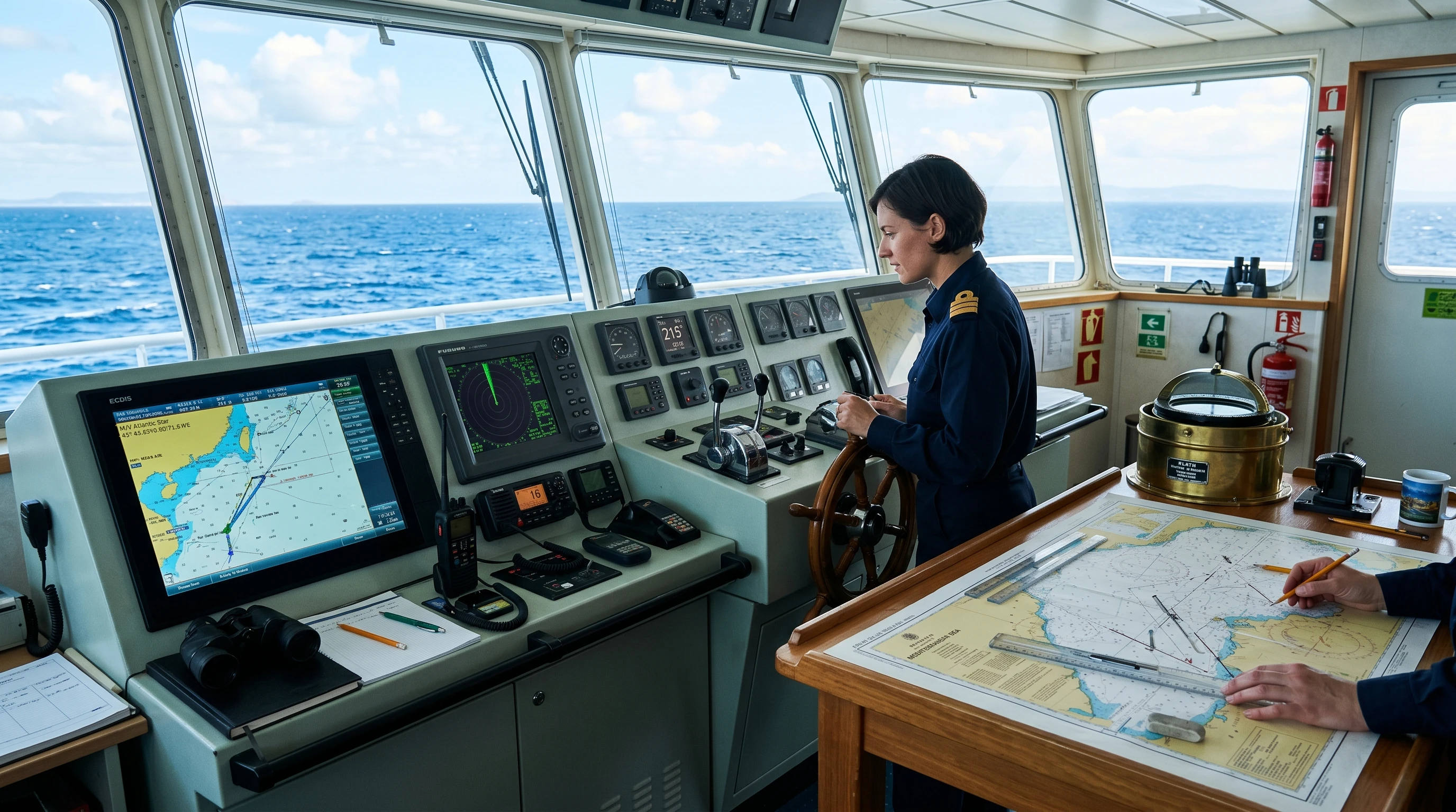
Modern Marine Navigation Tools and Devices
The basic compass used to be enough, but now we have several marine gadgets. Here are the top marine navigation devices I use and recommend:
- Magnetic Compass: Still needed for basic direction and as a backup.
- GPS Chartplotter: Gives your exact position and shows it on digital charts in real time.
- Depth Sounder: Measures the water depth below you, helping to avoid running aground.
- AIS Receiver: Displays information about nearby ships, helping to avoid collisions.
- Autopilot: Steers the boat using set compass directions.
- Tablet or Smartphone Navigation Apps: Offer portability and fast updates.
Combining devices expands what you can do and adds safety if one system breaks down. I personally keep a magnetic compass and paper chart within reach no matter how many screens I have on my boat. New developments in batteries and waterproof cases for tablets continue to make these tools even more reliable for open-water trips. Some newer boats are being designed with built-in charging ports to make it easy to keep devices topped up throughout a long day.
Chart Plotting Techniques for Sailors
Being able to plot a position on a chart lets you check your route and position. Here’s how I do it:
- Find your latitude and longitude either from the GPS or by estimating them using bearings and a compass.
- Mark the position on the chart with a pencil. If relying on the compass, use the bearings and distance traveled.
- Draw your intended course. Double-check for hazards along the route.
These classic chart-plotting techniques for sailors can be learned from books, classes, or online tutorials. Practicing with both paper and digital tools builds skill and confidence, especially if something goes wrong. I recommend setting aside time on each trip to manually plot your position in addition to trusting the electronics. Community sailing groups often run challenges and competitions in traditional navigation to help sharpen these skills in a fun setting.
Innovations in Marine Navigation 2026
Every year brings new technology in marine navigation that makes the process easier and safer. Augmented reality overlays can now display navigation information directly on a ship’s windscreen. Some new GPS plotters combine weather, depth, and traffic data in one place.
The future of marine navigation technology is likely to build even more on these trends. Expect tools that use artificial intelligence to recommend safer routes or even automatically prevent collisions. As smartboats and connected devices expand, you’ll see more features that don’t just guide you but also watch for danger and help with planning. More equipment is connecting to smartphones, making updates and route sharing as easy as texting a friend. Boaters are becoming more comfortable with sensors that track boat health and give early warnings about engine issues or changes in sea state. In just a couple of years, these upgrades could make small-craft boating safer for families and solo sailors alike.
Best Practices for Using Marine Charts
Whether I’m planning a long passage or a day trip, I stick to some best practices for using marine charts:
- Always check for the latest chart updates or corrections before setting out. The sea changes, and so do charts.
- Cross-check digital information with your paper chart. I often find differences worth noting before they become problems.
- Use parallel rulers and dividers with paper charts for more accurate course plotting.
- Pay attention to tidal and current information shown on the chart, especially in narrow passages.

Many marine navigation tutorials online offer free lessons on these topics, and even experienced sailors benefit from a refresh every so often. Practicing steady chart reading is super important any time technology is involved, because it prevents simple but costly mistakes. New chart apps now offer pop-up safety reminders and route checks, making it easier to focus on critical details before getting underway.
Things to Think About Before Relying Only on Modern Navigation
Technology has made marine navigation much easier, but there are some things that I always think about before depending fully on modern tools:
- Power Loss: Electronics need batteries or the boat’s electrical system. If something fails, I depend on my paper charts and compass.
- Software Bugs: Like any computer, there can be updates or glitches. Testing your devices before leaving port can prevent stress when you are on the water.
- Signal Loss: GPS signals are usually reliable, but they can fade due to weather, interference, or location.
- Overreliance: I see people stop learning actual seamanship because their phone does everything. The basics matter when something unexpected goes wrong.
Intentionally practicing without electronics is one way I make sure I’m ready for real-world issues. I recommend using both old and new systems on every trip. Seasoned sailors often run “no electronics” days on the water to see how crews manage classic navigation in busy or tricky spots.
Advanced Chartwork and Navigation Tips
Once you’re comfortable with the basics, a few advanced skills can really give a boost to your navigation:
- Dead Reckoning: Track your position over time using compass bearings and speed when GPS isn’t available. This keeps you aware of where you are even in thick weather.
- Fix by Bearing: Take compass bearings to known landmarks or buoys. Where the lines cross on the chart is your actual position. This skill is really useful on coastal routes.
- Radar and Overlays: Some digital chart systems let you overlay radar returns on the chart. This is helpful at night or in fog, letting you see both charted objects and actual returns at once.
- Manual Distance and Time Calculations: Being able to estimate arrival times based on charted distances and speed helps with planning and safety if forecasts change or engines slow down.
Practicing these skills is something I find satisfying and reassuring. Many online marine navigation tutorials cover these topics with step-by-step instructions. Boat simulation programs available for home computers offer sailors a low-risk way to practice these advanced skills, and some even mimic real-life emergencies so you can test your responses when things do not go as planned.
Common Questions About Charts and Compasses in the Digital Age
Marine navigation raises many questions for those just starting out or looking to upgrade their skills. Here are a few questions I get asked all the time:
Question: Are paper charts still relevant with all the new technology?
Answer: Paper charts are still really important as a backup, and I use them for big-picture planning and when electronics fail. Coast Guard rules in most countries also require having current paper charts on board.
Question: What are the practical differences in digital charts vs paper charts?
Answer: Digital charts are often more detailed, easy to zoom in and out, and are updated constantly. Paper charts are always visible, don’t run out of battery, and are great for teaching basic navigation skills.
Question: What’s the best way to learn navigation skills?
Answer: I always suggest practicing with both paper and digital tools. Lots of marine navigation tutorials online make learning easier, and real-world practice on the water is the best way to build confidence.
Question: How do I choose the right marine navigation tools in 2026?
Answer: Start with a good compass and current charts. Add a GPS chartplotter for ease, and consider redundancy, such as a backup handheld GPS or navigation apps. Look for tools that suit your boating area and travel type. Some newer tools even recommend planning software that checks for local hazards and reviews navigation strategies from local sailors.
Real-World Uses: How Compasses and Charts Save the Day
In my experience, some of the most stressful moments at sea happen when the weather comes in fast or visibility drops. On a long passage down the coast, my main GPS failed just after sunset. Having paper charts and a solid compass kept me on course throughout the night. Another time, chart plotting skills helped me find a safe anchorage when the app had outdated info about the harbor.
These real-world examples remind me of how valuable it is to build skills with both classic and new marine navigation technologies. Crew members with real navigation skills remain valuable even on the most high-tech boats. Maintaining confidence and skill with charts and compass isn’t just about tradition. It also ensures safety, peace of mind, and makes the entire trip more enjoyable, no matter how far offshore you roam.
Looking Ahead: The Future of Marine Navigation Technology
I’m excited about what’s coming in the future of marine navigation technology. More integration between devices, better real-time information sharing, and training tools that use virtual reality will help everyone, from weekend sailors to shipping companies, improve safety and experience. But at the heart of it, knowing how to use a compass and a chart is something I don’t see going out of style, no matter how smart the tools get. I always keep these classic tools nearby to stay ready for any challenge the open water brings.
This article was created with AI assistance and reviewed by a human editor.
About The Author


