Marine navigation systems have become a major component of modern sailboating. Whether you’re planning a quick day sail or plotting a weeklong adventure, having reliable marine navigation technology for sailboats helps keep things steady and safe. My experience has shown me these tools go far beyond simply reaching a destination. They boost confidence, improve efficiency, and offer peace of mind while out on the water. If you’re just starting out or want to upgrade your setup, let me break down how to choose marine navigation systems and which features to focus on if you’re new to boating technology.
Why Marine Navigation Systems Matter for Sailboats
Once you get out on the water, things can change in a flash. Sudden fog, unexpected currents, and shifting weather are always possibilities. Marine navigation technology for sailboats is there to help you decide what to do with real-time information. I depend on my navigation system for every trip, even on well-known routes. It combines GPS positioning, charts, wind speed, depth, and more. This combo helps avoid hazards such as shallow banks, busy shipping lanes, and underwater obstacles.
The main purpose of a solid marine navigation system is to help you plot courses, keep tabs on your position, and sail safely. Technology has come a long way; back then, everything was done by hand with paper charts, compasses, and dead reckoning. Traditional skills are still valuable, but now you can enjoy the ride more and stress less about getting lost.
Types of Marine Navigation Systems for Sailboats
Modern marine navigation systems come in different forms. As a beginner, it helps to understand the basics of what each one does:
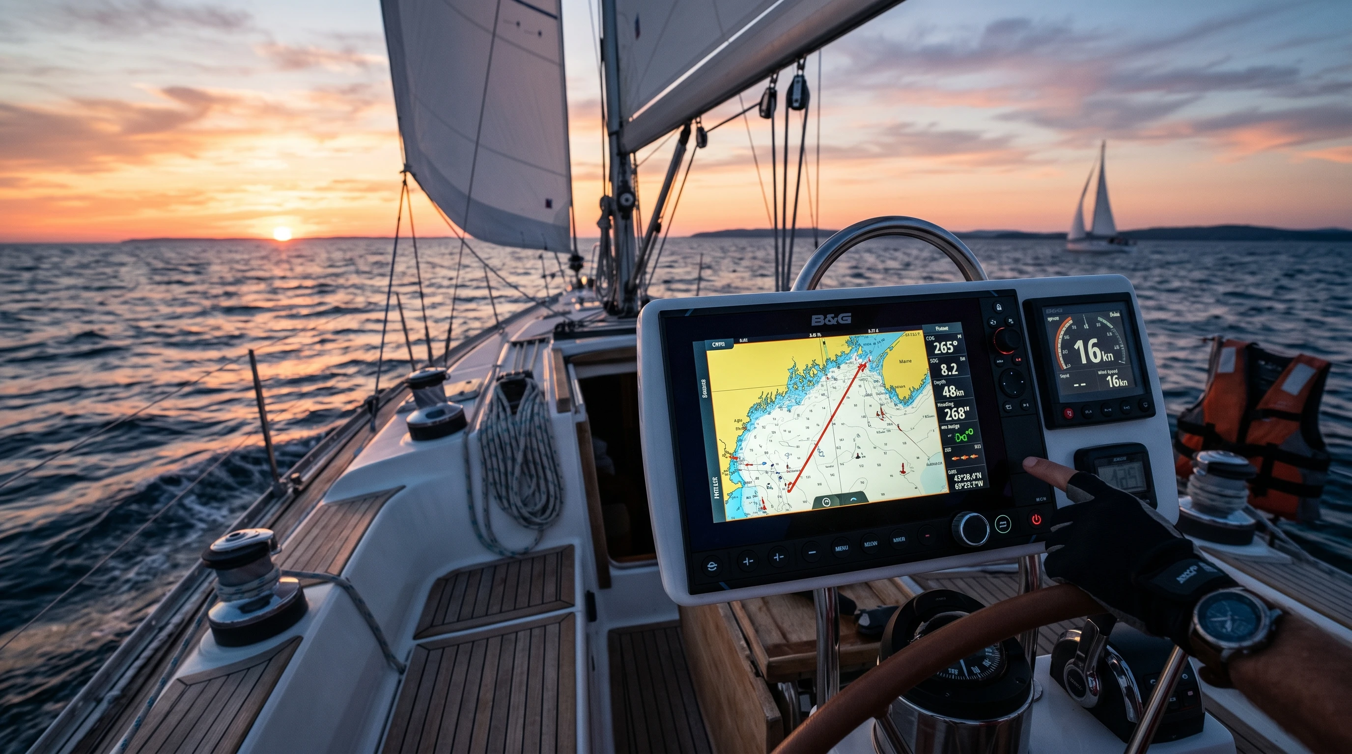
- Chartplotters: These devices display digital nautical charts that update as you move. They pair GPS and map data, so you always see where you are and your route.
- GPS Receivers: Basic GPS units offer your position, speed, and heading. Standalone GPS is simple and dependable, but usually won’t display charts.
- Multifunction Displays (MFDs): These touchscreen devices combine chartplotter, radar, sonar, wind data, and more in a single display. I prefer these for their flexibility and convenience.
- Tablet and Smartphone Apps: Many sailors love navigation apps. They provide digital charts, route planning, and weather data, often with automatic updates. Make sure you have a waterproof case and backup power as phones and tablets are vulnerable to moisture and battery loss.
Choosing the option that best matches your needs and budget plays a big role in how enjoyable your time on the water will be.
Features of Modern Sailboat Navigation Systems
The best navigation tools offer a host of practical features. Here are details I find important when checking out the options:
- Touchscreens and User-friendly Menus: Easy-to-use navigation controls make setup and changes swift. When under pressure, large screens and straightforward menus help avoid errors.
- Integrated GPS: Most devices use highly accurate GPS tracking. Look for strong specs, especially if you travel offshore.
- Weather and Tide Updates: Real-time weather and tidal data help plan safer trips and adjust routes.
- Charts and Map Availability: Some systems come preloaded with charts, others allow for downloads and updates. If you plan to sail outside your home region, double-check that your system covers the area you intend to sail in.
- Depth Sounders and Fish Finders: Depth readings help prevent accidental groundings. Some chartplotters integrate with echo sounders to highlight shallow zones.
- Autopilot Integration: High-end systems can plug into your sailboat’s autopilot, greatly simplifying navigation and corrections.
- Wireless Connectivity: Bluetooth, WiFi, and mobile device integration let you control maps and access system details remotely.
Picking the right features for your skill level and plans helps ensure you get a system that truly suits you.
How to Choose Marine Navigation Systems
Jumping into the choices can feel overwhelming for newcomers. Here are my main steps to narrowing things down:
- Pin Down Your Budget: Costs range from affordable handheld GPS units to premium multifunction displays. List the must-have features first.
- Think About Your Sailing Plans: For coastal cruising, a basic GPS and a chartplotter might be enough. If you want to go offshore, you’ll want advanced functions such as radar overlays and weather services.
- Consider Power and Backup: All electronics require a stable power supply. Make sure your sailboat’s battery system can handle new devices, and always keep a backup plan, such as paper charts or an extra GPS.
- Check Compatibility and Room for Growth: Make sure your new system integrates easily with other installed electronics, such as wind or speed sensors. Always keep future updates and upgrades in mind, from charts to software.
- Look for Real Reviews: Peer experiences are very helpful. I always check sailing forums or chat with local sailors before making a big purchase. People often point out key strengths and weaknesses that the marketing materials won’t mention.
Matching a navigation system to your boat, sailing style, and technical know-how makes each trip more enjoyable and less stressful.
Marine Navigation Systems for Beginners
If you’re just getting started, staying simple is wise. Here are some beginner-focused tips for marine navigation systems:
- Stick to the Basics: Start with a basic chartplotter or GPS app on your phone or tablet. Learn the fundamentals: plotting routes, reading charts, and marking waypoints.
- Make Ease of Use a Priority: Choose devices with straightforward menus and clear on-screen help. Some brands design their interfaces just for beginners, so you’ll have an easier time learning as you go.
- Find Built-in Tutorials: Many starter models include step-by-step guides or videos, which you can use directly on your device out on the water.
- Paper Charts as Backup: Never leave home without paper charts for your region, even if you mainly use electronics. If electronics fail, this backup can be a trip saver.
- Check Out Local Sailing Classes: Most sailing schools now show you how to use marine navigation technology for sailboats alongside traditional techniques. This can greatly speed up your learning curve and build your confidence.
Common Questions from New Sailors
If you’re new to marine navigation systems, questions always come up. Here’s what I hear the most:
What if my system loses power or malfunctions?
Always bring backup batteries or a portable charger if possible. Also, pack a waterproof bag with paper charts, a compass, and some emergency gear, just in case.
Should I update my electronic charts?
Absolutely. Channels move, hazards appear, and buoys are repositioned. Look for updates before each season, and especially before major trips.
How precise are marine navigation systems?
Most GPS-based systems are accurate within about five meters. I like to double-check by cross-referencing electronic positions with real-world landmarks or nav marks whenever possible.
Are free marine navigation tools worth it?
Some apps are free or inexpensive, but they might require an internet connection for updates. For regular or long-distance use, a dedicated device is well worth the investment.
Real-Life Navigation on a Sailboat: An Example
The first time I used a chartplotter, I was amazed how much easier it made route planning. Along the coast on one trip, a wall of fog rolled in, and visibility dropped off quickly. My chartplotter let me keep track of my exact spot and all the nearby buoys, so I could steer clear of trouble. Since then, even when I know the route perfectly, having these digital tools feels like sailing with an extra set of eyes that never gets tired.
When sailing in new places or after sunset, having several features linked up is a real advantage. I can see wind instruments, autopilot details, and navigation all on one screen—keeping my hands free and my mind clear, so sailing is less complicated and more fun.
Next Steps: Getting Comfortable with Your Navigation System
If this technology is new for you, practice in familiar waters first. Plot simple routes, create and follow waypoints, measure distances, and update your charts regularly. Using both your electronic tools and time-tested navigation methods will build up your confidence. I strongly recommend testing “what if” scenarios, such as taking a detour if your route gets blocked or switching to paper charts if electronics fail. Building these habits helps you stay sharp and makes learning by doing much easier, which adds to the enjoyment of each trip on your sailboat.
This article was created with AI assistance and reviewed by a human editor.


