Finding more fish quickly has always been the goal for anglers like me. High-tech fish finding solutions have changed the way I approach my time on the water, and smart sonar mapping technology has taken things to a new level.
Whether you fish deep sea or prefer coastal trips, using a Deeper marine GPS combined with advanced sonar mapping can help you track down, analyze, and track fish like never before. I’m breaking down everything I know about these cutting edge devices, the technology behind them, and how you can get the most value out of these tools during your next fishing trip. I’ll also share some first-hand tips and sample setups designed for every type of angler, from beginners to pros.
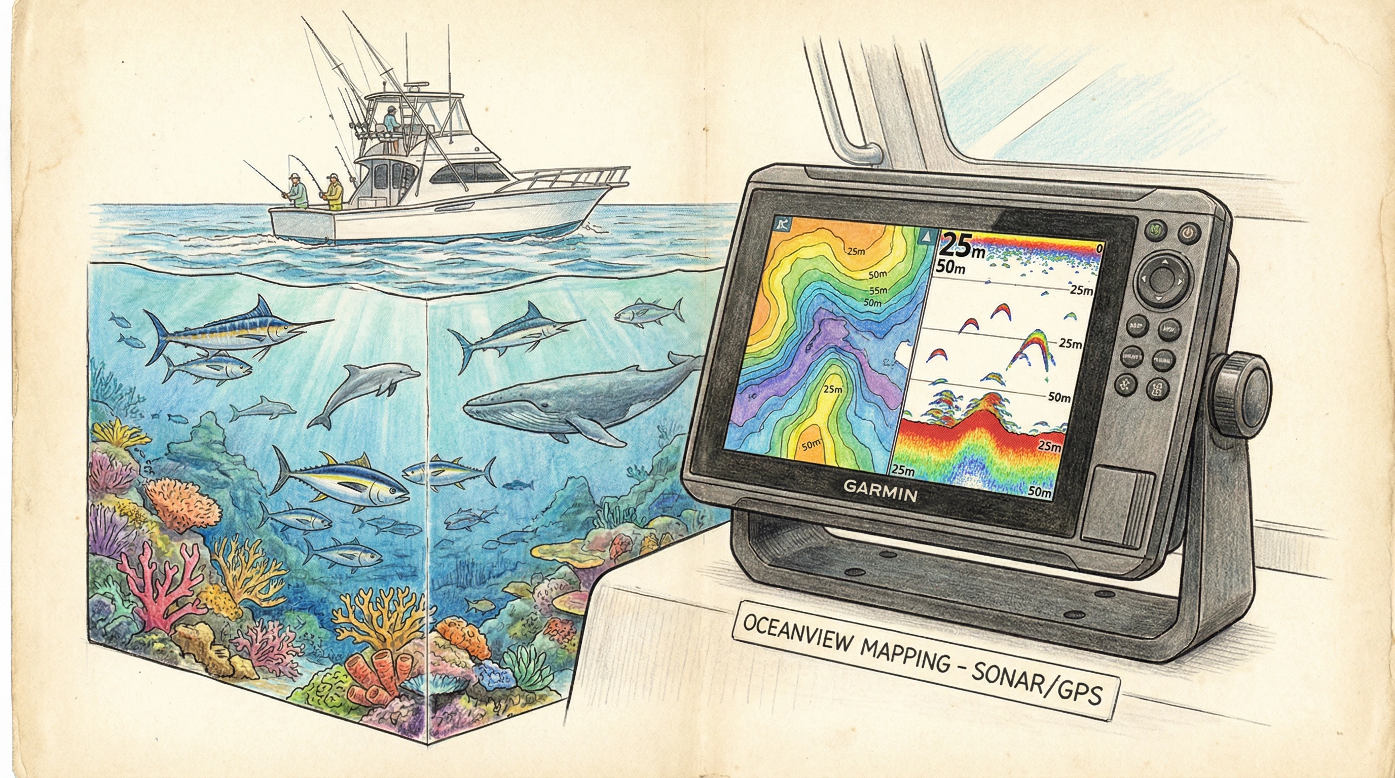
How Smart Sonar Mapping Technology Works
Smart sonar mapping technology uses sonar waves to scan underwater environments and relay the information back to your device as easy to read maps. Unlike the old school fish finders that only gave a simple sonar return, smart sonar mapping devices, like the Deeper marine GPS, show me detailed bottom contours, structure locations, and actual fish targets.
These devices work by sending acoustic pulses through the water. When the sound waves hit an object, such as a rock, a sunken tree, or a group of baitfish, they bounce back up to the receiver. The smart mapping system then processes those signals to create a visual underwater map. This lets me see drop offs, ledges, submerged structures, and even track the movement of fish over time. Many units connect through WiFi or Bluetooth, so I get real time access on my smartphone or tablet. I also like that I can save maps to review before my next trip.
Sonar mapping’s key innovation is how it turns raw data into visuals anyone can understand. Instead of just seeing random dots, you’ll see color coded returns that show dense structure and fish, making it easier to spot where you should be casting. Advanced devices can even “learn” from your past trips, remembering your favorite spots and showing historic fish activity, so your chances of success go up as you get more familiar with your favorite waters.
Why Using a Marine GPS with Advanced Sonar is Game Changing
Combining GPS with deep sea fishing sonar devices has really changed the way I fish. Here are a few practical reasons why I wouldn’t want to go back:
- Precision Location Marking: I drop a waypoint whenever I find a hotspot. By pairing GPS and sonar, I can return to that exact spot on future trips, even in open water.
- Structure Identification: The sonar mapping tools help me find reefs, humps, brush piles, and channels that hold fish. I no longer waste time fishing empty areas.
- Depth and Temperature: The system shows me temperature breaks and thermoclines, so I know where fish may be schooling, especially in deep sea environments.
- Data Tracking: Most smart sonar mapping units let me log catches, note underwater conditions, and compare previous trips. This helps me spot patterns over time and catch more fish.
I’ve noticed that using a GPS with sonar mapping keeps me focused, organized, and ready to adapt whenever something unexpected comes up. It’s easier to stay safe, too, since you always know your exact location, no matter how far you wander from shore. These units can even help retrace your route in bad weather or low visibility.
Choosing the Best Sonar Mapping Tools for Anglers
Picking the right technology can feel overwhelming. I use a few key factors to guide my choices when it comes to selecting the best sonar mapping tools for anglers. Here’s what I consider:
- Frequency Options: High frequency sonar gives me clear images of structure and fish, while lower frequencies are better for scanning deeper waters.
- Display Quality: I prefer units with color screens and sharp resolution, so bottom features don’t blend together.
- Portability and Mounting: Some smart sonar mapping technologies, like Deeper, are castable and work with smartphones, while others mount directly to the boat. I choose what best fits my typical fishing trip.
- Integration: The best devices sync with GPS, let me export maps, and connect to other accessories like trolling motors or chartplotters.
Careful research helps buyers make informed decisions here. Product reviews, demo videos, and hands on store testing can help you figure out what feels right and performs reliably over time. Also, consider the type of fishing you do most. If you fish both lakes and saltwater, choose a device that’s flexible and easy to adjust for different waters.
How to Use Sonar for Fishing, My Step by Step Routine
Using smart sonar mapping isn’t complicated once you get the hang of it, but there is a learning curve if you’re new to it. Here’s how I approach it every time:
- Startup and Calibration: I make sure my sensors are in the water and my app or screen is set up before I start moving.
- Initial Scanning: I do a slow pass over fishing grounds while watching the sonar maps fill in with structure, depth changes, and any sign of bait or predatory fish.
- Interpret the Returns: Arches and solid blips mean fish. Steep changes in contour lines show me drop offs that often hold predators.
- Mark Spots: When I see something promising, such as a school, a weed bed, or a ledge, I mark the GPS location.
- Fish and Track: I drop a line, then use the sonar to watch my lure and monitor how fish react. Sometimes I see them charge up or swim away, and I adjust my technique from there.
- Review Data: After a few trips, I look over saved sonar maps, GPS tracks, and catch history to plan future outings.
This routine has helped me avoid “dead water” and spend more time in productive zones. Practice helps a lot, and after a few outings, reading the screens and making sense of the signals starts to feel natural. I also suggest exploring your local waters in off season months when you’re not as focused on catching, so you can learn how your sonar behaves in different conditions with less pressure.

Deep Sea Fishing Sonar Devices: What Sets Them Apart?
The demands of deep sea fishing are different from inshore or lake fishing. Deep sea fishing sonar devices need serious power to cut through hundreds or even thousands of feet of water and bring back useful images. I look for these practical benefits when choosing a sonar device for offshore trips:
- Long Range Coverage: Offshore units scan wider areas and reach deeper depths, perfect for finding big game fish.
- Chirp Sonar Technology: Continuous sweep frequencies give clearer returns and help separate bait from predators.
- Ruggedness: Saltwater, rough weather, and constant spray mean I prefer sealed, corrosion resistant devices.
- Split Screen Display: Viewing both navigation charts and sonar returns on one screen saves me time.
Pairing GPS and sonar is especially helpful offshore, where underwater landmarks are harder to find by sight. With these systems, I can build and share custom saltwater maps with my friends and plan trips around underwater ridges that often attract fish. I’ve joined online communities where folks trade their mapped routes and trade notes, giving everyone an edge on their next trip.
For deep sea fishing, always bring a backup device and waterproof cases for critical electronics. Ocean conditions can change rapidly, and proper planning ensures you get home safely even if one device acts up.
Eye Catching Innovations in Fish Finding Technology
The pace of fishing tech glow up has picked up a lot in the past few years. The fishing technology trends for 2026 point toward even smarter devices, with automation, machine learning, and seamless connectivity. Here are some next level cool developments I’m watching:
- AutoCharting and 3D Imaging: Devices can create three dimensional maps in real time, letting me “see” the bottom like never before.
- Wireless Casting Units: Ball shaped sonars, like the Deeper CHIRP series, connect to my phone from up to 300 feet away, so I can map shorelines and remote spots.
- Real Time Data Sharing: Some apps allow anglers to upload, sync, and share custom maps so the whole fishing community can benefit.
- Integration with Wearables: The latest watches and fitness bands can show me notifications from my sonar app or buzz when fish appear on the screen.
I recommend checking for compatibility with other gear, software updates, and cloud storage features when shopping for a new device. Technology continues to mix it up, so I like units that are ready for updates and improvements over time. Consider warranties and future proof features if you’re planning to fish for years to come.
Popular Applications and Real World Use Cases
Smart sonar mapping isn’t just for hardcore saltwater anglers. I see benefits for recreational fishers, tournament pros, kayak anglers, and even scientists. Here’s how different groups use these tools:
- Recreational Anglers: Spending less time searching and more time landing fish means more fun for everyone.
- Kayak and Shoreline Fishing: Compact and wireless sonar units open up areas that larger boats can’t reach.
- Tournament Fishing: Fast, reliable mapping saves valuable time during high stakes competitions.
- Fish and Wildlife Research: Scientists map habitats and monitor populations to protect aquatic resources.
I often combine sonar tech with traditional tactics—like watching bird activity or noting water color changes—to stack the odds in my favor. Combining methods makes each trip more productive and more interesting too. In education, fishing guides even use these displays to teach newbies about underwater features and how fish behave, creating better learning experiences for everyone aboard.
Overcoming Common Challenges with Sonar Mapping and Marine GPS
No fishing technology is perfect. Here are a few common challenges I run into and how I manage them:
- Battery Life: I bring extra batteries or a portable power pack, since scanning and mapping can drain power quickly.
- Signal Interference: Heavy vegetation, muddy water, and electronic “noise” from other onboard electronics can affect signal clarity. Adjusting frequencies or turning off unused gear usually helps.
- Data Overload: Early on, I felt overwhelmed by all the information on screen. I focus on one or two variables, such as depth and structure, and tune out extras until I need them.
- Learning the Interface: Different brands have different menu layouts. Watching tutorial videos and using practice mode before going out makes a huge difference.
Everyone will face bumps in the road, but simple preparation and patience go a long way. I find it really helpful to take guided trips or buddy up with experienced sonar users to jumpstart my learning curve. Don’t forget safety, using tracking features can help if you need to signal for help or share your location in case of emergency.
Gear Maintenance and Storage
With all the moisture and salt involved in fishing, gear upkeep is really important. Here’s what I do to keep my sonar mapping units and marine GPS working their best:
- Rinse everything with fresh water after every trip, especially in saltwater.
- Dry connectors and screens before storing.
- Update software regularly for the latest features and stability.
- Check for corrosion and replace worn cables or batteries as needed.
Good maintenance habits keep the investment working for years and prevent frustrating breakdowns on the water. In addition, store your units in cushioned cases and avoid leaving electronics in extreme heat or cold, which can shorten their lifespan.
Expert Tips for Getting the Most from Your Sonar Mapping Setup
Once I got the basics down, I started picking up tricks from guides, tournament anglers, and YouTube creators. Here are some advanced tips that helped me catch more fish:
Fine Tune Sensitivity Settings: I adjust sensitivity as conditions change. In clear water, turn it up for subtle targets. In murky or busy spots, dial it down so clutter doesn’t jam the screen.
Scan at Different Speeds: Fast passes are good for covering lots of water, but slow, overlapping scans reveal tiny details that big fish love to hide near.
Read the Edges: Fish and structure often line up at the boundaries of drop offs or vegetation. I always check these edge zones carefully.
Keep Notes: I jot down conditions, catches, and hotspot locations right in the sonar app or a notebook, so I can build a personal fishing handbook over time.
Practice Casting with Ball Style Sonars: Castable units need smooth, steady casts and retrievals to produce readable maps. Avoid cranking too fast or too slow.
Continued learning keeps things fresh, and it’s satisfying to watch results improve each season as my understanding of sonar mapping grows. Practice in different weather, water types, and at different times of year to discover even more tricks that help you find fish fast.
Frequently Asked Questions About Smart Sonar and GPS
Many new users have questions before buying their first marine GPS or sonar tool. Here are answers to a few things I’m asked most often:
Question: How deep will these smart sonar mapping units work?
Answer: Most smart units like Deeper work well from two feet to over 260 feet, with some deep sea models reaching much further. Always check specs before buying if you fish offshore.
Question: Can I use my phone as the display screen?
Answer: Yes, a lot of smart sonar units pair directly with smartphones or tablets, making setup simple and portable. Just make sure your phone is waterproofed for safety.
Question: How accurate are the fish icons?
Answer: Fish icons are helpful, but it is better to learn what real fish marks and underwater features look like on the raw sonar to avoid confusion with debris or air bubbles.
Question: Can I use smart sonar and GPS from a kayak or from shore?
Answer: Many castable sonar mapping tools are designed specifically for kayak and shore anglers and are lightweight, waterproof, and connect wirelessly to your phone.
2026 Fishing Technology Trends Worth Watching
I’m always interested in where fishing technology is headed. Based on what’s releasing now and what industry insiders are teasing for the future, here’s what I expect to see by 2026:
- Adaptive sonar that automatically adjusts settings for water depth, temperature, and clarity for a plug and play experience.
- Integrated all in one units, combining chartplotters, engine controls, lights, and sonar mapping in a single hub.
- Augmented reality overlays, projecting underwater maps and fish marks right onto smart glasses or helmet visors.
- Community driven mapping, with real time updates fed by crowdsourced data from other anglers wherever I fish.
- More ecofriendly power sources like solar or rapid charging lithium packs, letting me stay on the water longer and lighten my load.
Staying updated with these advances helps me plan gear upgrades at the right time and get the most from every fishing adventure. The underwater world is always changing, and having access to the latest trends and technologies gives any angler a significant advantage.
Whether you’re aiming for trophy catches or just hoping to make every trip more fun and productive, using smart sonar mapping and GPS can transform your fishing. Careful habits, a little practice, and staying up on the latest tech will help you find more fish faster, every season. As you try new setups and learn what works best in your favorite waters, you’ll quickly see your skills jump up a level and your catches increase.
About The Author


Wow, I didn’t know that you can use GPS to find fish, but doesn’t that somehow feel like cheating? In the past fishermen had to guess where all the fish were and take chances and sit for hours on certain spots hoping for the best, but now technology has changed all that and things almost seem too good to be true.
Thank you for the extra tips that you have given in order to avoid ‘dead water.’
That’s a really interesting point, and honestly, I think a lot of anglers feel the same way at first.
On one hand, tools like GPS and fish finders definitely take away some of the guesswork that used to be a huge part of fishing. Back in the day, it was all about reading the water, knowing seasonal patterns, and a lot of patience. Sitting for hours not knowing if anything was even there, that was just part of the experience.
But on the other hand, technology doesn’t guarantee success, it just gives you better information. You still need to understand fish behavior, choose the right bait, present it properly, and adapt to conditions. Even with the best gear, fish can ignore you all day if you’re not doing things right.
Some people see it as cheating, others see it as just another evolution, like better rods, stronger lines, or more realistic lures. At the end of the day, it really depends on what you personally enjoy about fishing. If you love the old-school challenge, you can always limit yourself and fish more traditionally.
And I’m glad the tips about avoiding dead water helped, that alone can make a huge difference, with or without tech.