
Marine GPS for Fishing can completely change how I find and track fish out on the water. Reliable GPS not only helps me stay aware of my location, but it also gives me tools for marking the best fishing spots and staying safe when conditions change. With so many models and features out there, picking the right marine GPS might feel overwhelming at first. Here, I’ll share what I’ve learned about choosing and using GPS units designed specifically for fishing, so you can make the process easier and get the most out of your time on the water.
Why Marine GPS Is So Useful for Fishing
A marine GPS is one of those tools that keeps me efficient, helps me avoid hazards, and lets me focus on the fishing itself instead of worrying about getting lost or missing out on good spots. GPS stands for Global Positioning System, which uses satellites to pinpoint my location anywhere on the water within a few feet. When I’m fishing, this makes it much easier to find dropoffs, reefs, wrecks, or other places where fish like to gather.
Marine GPS devices are different from the GPS I use in my car or on a hiking trail. They’re made for wet environments, usually have bigger screens, come with charts for waterways, and have buttons or touchscreens that work even if my hands are wet or cold. For fishing, the biggest benefit is that I can mark spots (called “waypoints”), record trails I’ve followed, and plot routes safely around obstacles or shallow areas.
Types of Marine GPS Devices for Fishing
Before picking a GPS, I like to think about where and how I fish. The main categories that make sense for most anglers are:
- Handheld Marine GPS: Portable and rugged, these are easy to take on kayak, canoe, or if I need something small for backup. They usually run on replaceable batteries.
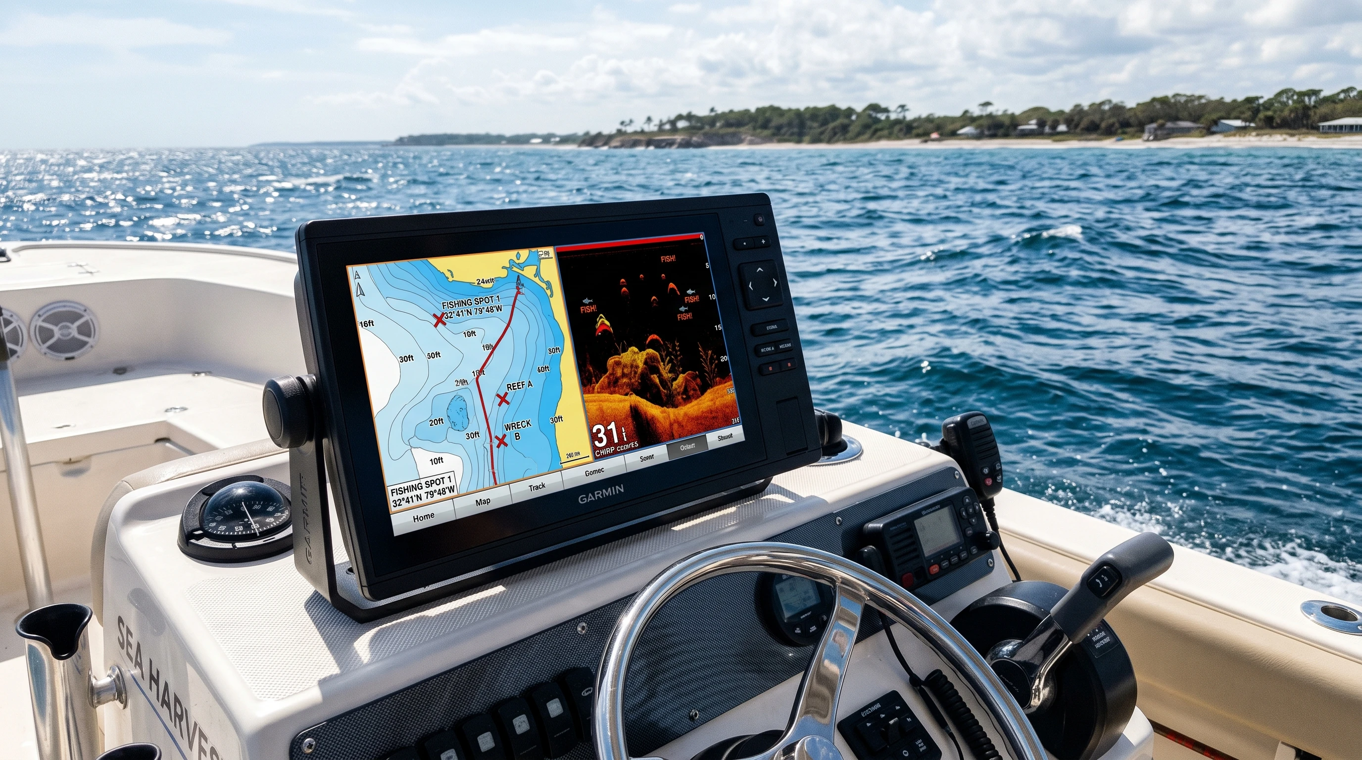
- Fixed Mount Marine GPS: These mount to my boat and usually have bigger screens. They plug directly into the boat’s battery and offer more features, such as integration with fish finders or radar.
- Combo Units (GPS/Fish Finder): These devices do double duty, using sonar to display what’s under the water and GPS to keep my location accurate. They save space and often make it easier to spot fish.
Each type has its own pros, depending on my boat size, fishing style, and budget. For instance, a fixedmount GPS might be overkill for a small kayak, but ideal for a cabin cruiser or bass boat. Conversely, a handheld GPS is lightweight and perfect for bank anglers or those who fish from canoes, where mounting larger devices isn’t practical.
Core Features in Marine GPS For Fishing
To make sure I pick a GPS that works well for my fishing needs, I always check several key features:
- Waypoints and Track Recording: Creating and saving waypoints means I can mark the best fishing holes or obstacles, so I never lose track of them. Track recording shows me exactly where I’ve traveled, letting me build a personal map of productive waters over time.
- Chartplotting: A built-in electronic map, or “chart,” shows my surroundings and makes it easy to plan safe routes and return to favorite spots. The better the chart detail, the easier it is to avoid underwater hazards.
- Waterproof and Weatherproof Build: Saltwater, rain, and splashes are inevitable. I look for ratings such as IPX7, which means the device can survive being dropped in water for at least half an hour. Real-world conditions demand gear that can stand up to constant exposure.
- Display Readability: On sunny days, I want a screen that’s bright and easy to read. Some come with antiglare coatings or high contrast settings for this reason. Touchscreen units that are responsive even with wet fingers offer extra convenience.
- Battery Life or Power Options: Long trips call for a GPS that lasts the whole day, or one that plugs into my boat for all-day use. Backup battery options give peace of mind for extended outings.
- Mapping and Updates: Some GPS devices come with detailed charts of lakes, rivers, and oceans. The ability to update or add new maps is really useful when exploring new places, keeping your information accurate as waterways change.
- Networking and Integration: Many modern units connect to other boating instruments, or let me share waypoints with friends, which helps during group fishing trips. Linkups with autopilot, radio, or weather overlays can make a big difference in convenience and safety.
How Marine GPS Helps Me Catch More Fish
Having a marine GPS on board isn’t just about knowing where I am. It actually gives a boost to my chances of catching fish in several ways:
- Repeat Success: By marking productive fishing locations as waypoints, I can go back to those exact spots trip after trip, even when the weather changes or visibility is bad. This consistency is a big perk for serious anglers.
- Improved Safety: I can set up routes and waypoints that keep me away from shallow rocks, buoys, or other dangers, even if fog rolls in unexpectedly. Safety is just as vital as catching fish.
- Tracking Fish Movements: By connecting with fish finders, some combo GPS units give me a constant view of fish, structure, and the contours where fish like to hide. It’s like having eyes underwater.
- Saving Time: Instead of guessing, GPS lets me go straight to the depths, dropoffs, or wrecks where fish gather, letting me maximize my time.
For example, I once mapped a promising stretch of underwater ledge at a reservoir and marked the start and end points as waypoints. Each visit after that, I could find the exact spot from my previous successful outings, even in early morning fog. Those waypoints became a personal treasure map of sorts.
Getting Started: Setting Up a Marine GPS for Fishing
Setting up a marine GPS doesn’t have to be complicated. Here’s a step-by-step process that’s worked for me:
- Install or Power Up: For fixed units, mount the device securely and connect to the boat’s battery. For handhelds, make sure the batteries are charged or loaded in. Placement matters—make sure the antenna has a clear signal to the sky for the most accurate readings.
- Select and Adjust Charts: Load or update the right maps for your area. Some devices require me to adjust the compass or set up my preferences for depth, speed, or tides.
- Save the Dock or Launch Site: I always mark the spot where I start, which helps me get back safely, especially if the weather changes or it gets dark suddenly.
- Practice Marking Waypoints: Whenever I find a good structure, fish, or underwater feature, I save it as a waypoint right away. This way, I never lose that honey hole.
- Plan Routes: Create safe paths between launch, fishing spots, and any stops along the way using the chartplotter. Planning in advance saves nerves later.
- Test Out Fish Finder Integration: With combo units, set up the sonar to see how it overlays info with GPS location. This helps me relate fish movement to my position on the chart, letting me react in real time.
- Check Weather, Tide, and Sun Data: Some advanced GPS devices provide weather alerts or tide charts to help me plan fishing windows and avoid sudden changes in conditions.
With these steps, my first trips with a new GPS device feel much less stressful, and I start building a record of productive locations right off the bat. Keeping everything organized early makes every future trip smoother.
What to Watch Out for When Buying Marine GPS for Fishing
I always look for a few common issues when choosing or using marine GPS devices, especially as a new buyer. Here are practical things to consider:
- Screen Size and Placement: A tiny screen is hard to read, especially in rough conditions. I try out different sizes to find what works for me and fits on my boat. If you fish at night, backlit screens with adjustable brightness help a lot.
- Chart Coverage: Some products come with only basic charts. If I fish new lakes or coastal waters often, I choose a unit with wide coverage, or at least support for adding new maps. Extra mapping options are a worthwhile upgrade.
- Batteries and Power: Handheld units may run out of batteries on longer trips, so I carry spares. With fixed units, I check how much power they draw to avoid draining my starter battery. Taking good care of your power system means less downtime.
- Menu Navigation: Complicated menus or touch screens that lag can be frustrating or dangerous if I need information quickly. I check out demo models before deciding; clear menus keep things stress-free on the water.
- Waterproofing: Even “waterresistant” sometimes isn’t enough for saltwater or heavy rain. I stick to units certified for submersion if I regularly fish in tough conditions. Saltwater is much harsher than you may expect.
Chart and Software Updates
I check how often map updates are available and how easy it is to install them. Keeping charts current helps me avoid sandbars or channels that might have shifted since the last update. Some brands send update reminders via apps or email, so I never miss a critical enhancement.
Mounting and Wiring
If I use a fixedmount GPS, I pay attention to where and how it mounts. Tight spots in the dash, exposed wiring, or awkward placement can create problems. Clean wiring helps with long-term reliability, especially in saltwater environments. Professional installation may be worth it for complex setups, as it can prevent headaches.
Advanced Tips for Getting More out of Marine GPS
After getting comfortable with the basics, I’ve picked up a few advanced tricks that really help improve fishing results:
Layering Data: By using combo units, I layer GPS location, sonar views, and even side imaging on the same screen. This helps me match the map’s structure to the actual fish seen on the sonar, letting me connect the dots quickly.
Crowdsourcing Maps: Some brands, like Garmin, offer active map sharing, letting me upload my sonar recordings and get updated contours or “community” maps from other anglers. This opens up hidden fishing potential in lesserknown spots where official charts may be lacking.
Alarms and Alerts: I set up depth or proximity alarms to warn me if I drift too shallow or near hazards, so I can focus on fishing instead of checking my position every few minutes.
Downloading Routes: Before a big trip, I use online resources to research local fishing spots and download waypoints, routes, or known structures straight to my GPS. This saves time on the water and introduces new fishing possibilities I might never stumble upon otherwise. It always pays to plan ahead.
Common Questions About Marine GPS For Fishing
What’s the difference between a marine GPS and a regular GPS?
Marine GPS units are made for water use. They’re waterproof, have charts for waterways, are easy to read in the sun or rain, and are designed for use in wet, bumpy conditions. Built with anglers and boaters in mind, these devices shine where it counts.
Can I use marine GPS in freshwater lakes?
Yes, marine GPS works on any large body of water and is just as helpful in lakes as it is at sea. Some units offer detailed charts of lakes and rivers for even better accuracy. Whether you fish big reservoirs or small inlets, the technology adapts easily.
Is it really worth paying for a combo GPS/fish finder?
If I fish regularly and want to visualize structure and fish location on the same screen, a combo unit saves space and gives more information in a single glance. Even budget models now combine both features at a good price, making it a smart choice for many modern anglers.
Best Use Cases for Marine GPS When Fishing
Different kinds of fishing benefit from marine GPS in unique ways. I’ve used GPS in these situations for good results:
- Bass Fishing on Large Lakes: Pinpointing dropoffs, brush piles, or submerged roadbeds and returning to them later without guessing. In tournaments, marking schools of moving fish is a real gamechanger.
- Coastal Inshore Fishing: Navigating channels and backwaters where tides and shifting sandbanks can leave me stranded if I’m not careful. Accurate GPS helps me safely weave through tricky marshes.
- Offshore Deep Sea Fishing: Marking offshore reefs or wrecks and using chart plotting to keep safe on long runs out of sight of land. Offshore trips call for precise route planning and good contingency routes if weather changes quickly.
Friends who fish tournaments have told me that keeping a careful record of hot spots gives them a real advantage. Tracking waypoints makes it much easier to repeat past success and target high-producing areas under changing conditions.
How I Pick the Right Marine GPS For Fishing
My top priorities when picking a marine GPS always come back to the kind of fishing I do most. For kayak or canoe anglers, a simple handheld is often enough, as long as it’s waterproof and easy to use with one hand. On a bigger boat, I like a combo chartplotter/fish finder with a large screen, which makes reading maps and sonar easier in rough conditions. Regular chart updates and good customer support are really important, especially if I plan to fish different areas. Reading recent reviews from other anglers helps me spot any issues with updates, hardware, or reliability before I spend my money.
With a reliable marine GPS, my fishing trips become more productive, safer, and a whole lot more relaxing. Every trip gets easier to plan, and the technology handles much of the tasks involving navigation so I can focus on the thrill of the catch rather than logistics. Whether you’re a first-timer eager to track down your next trophy or a seasoned pro looking to step up your game, investing in the right device paying attention to features, and embracing a little bit of technology will absolutely give your fishing adventure a boost.
This article was created with AI assistance and reviewed by a human editor.


