Product: Garmin GPSMAP 78sc Waterproof Marine GPS and Chartplotter review
Cheapest Place to Buy: Amazon.com
Display: 2.6 inches
Coverage: Built-in BlueChart g2 U.S./Bahamas coastal charts with shorelines, depth contours, navaids, harbors, marinas, and more
Display Resolution: 160 x 240 pixels
Battery Life: 20 hours/2AA Included
Date First Available: April 23, 2010
______________________________________________________________________________________________
In my previous post, I did some research about Garmin Marine GPS system and came to the conclusion that this brand has become successful maritime navigation device manufacturers.
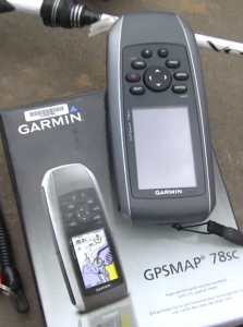
Let’s take a look at some of them. I will begin my Garmin Marine GPS Reviews series from budget range device. In fact, it is not the right term „budget range,“ I would say, a powerful Marine GPS for a reasonable price- Garmin GPSMAP 78sc Waterproof Marine GPS and Chartplotter.
The main features are stated in the name of the device but let dig a bit deeper in a style of classical review or my style if it sounds better. To be honest, when I read or listen that something is sooooo cool with so many incredible features I usually become cautious. It is the case.
See short description from Amazon.com
Marine-friendly handheld with high-sensitivity GPS receiver and 2.6-inch color TFT display
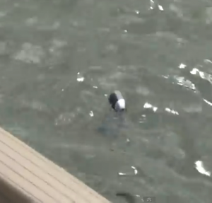
Perfect for boating/watersports–waterproof to IPX7 standards; floats in water
Built-in BlueChart g2 U.S./Bahamas coastal charts with shorelines, depth contours, navaids, harbors, marinas, and more
Built-in 3-axis tilt-compensated electronic compass and barometric altimeter for heading/altitude/weather
Share your waypoints, tracks, routes, and geocaches wirelessly with another compatible device user
The · Rugged case, Barometric altimeter, Garmin Connect compatible, Electromagnetic compass, Garmin HotFix, Custom POIs, Automatic routing, Hunt/fish calendar, Geocaching, Photo navigation
· Featuring a bright 2.6-Inch LCD color display with built-in basemap and high-sensitivity GPS receiver, the GPSMAP 78 series takes recreational navigation to a whole new level. All three models are waterproof, and include a built-in microSD card slot for loading additional maps and a dedicated MOB (man over board) button.
Sounds perfect, isn’t it?
And people really buy this Garmin device. I can say it with confidence because there are five devices purchased via my Amazon links even not promoting it directly. In my opinion, it is a good indicator.
Secondly, it is not the latest model of Garmin handheld GPS marine devices as first released back in 2010 but holding Best Seller label until now.
Finally, it is almost three hundred real customer reviews with five and four stars rating range is about 74% from total.
I forget one more detail to mention, even after six years there are almost not any other options out there in this category of marine GPS.
Well, let say that above written we can count as Pros.
What about Cons?
- There are some complaints about bad visibility in the sunlight.
- Small screen size. But by me, if you are not satisfied with size, just buy larger dimensions’ device.
- „Garmin has redesigned these things where they are not intuitive anymore and loaded with junk.“ It is a sentence written by one of an unhappy user. In my opinion, it is a bit exaggerated, but some truth there probably also are, as even some satisfied users sometimes complain about complicated procedures compared to older models like Garmin GPSMAP 76 (Discontinued by Manufacturer).
There are about five very aggressive users reviews about
insufficient waterproof capability. I believe that some of them could be real issues but on the other hand, there are much more satisfied users and even praising this GPS durability.I assume that there may be a factory fault or incorrect exploitation of the unit.
All in all the Garmin GPSMAP 78sc is a good choice for small watercraft as kayaks, ski jets or anglers. It could be used as backup safety GPS device on any other boat or yacht and even commercial fishing boat.
It could be said that iPhone or any other smartphone loaded with countless Navigation applications is a smarter choice vs small screen GPS navigator. Even assuming that it is water-resistant cases and even the phones themselves, as has just released iPhone 7 is presented as waterproof, I would not like to hold nearly 1K worth of phone to salty sea splashes or even accidentally dropped on the deck.
Is the Garmin GPSMAP 78sc the best choice?
Incorrect question.
It could be a good choice as far as you are seeing the merits and not paying particular attention to some shortcomings because nothing is perfect.
Fair winds and calm seas!


I love been in the sea. With our boat and jet ski’s and regularly hitting the waves, this device had been on our list for a while
To be honest with you, my wife scouted the Amazon site and we were happy with the reviews but need a more detailed report.
Your post sealed the deal for us. We share your same feelings about not wanting to use our smartphones for the navigation purpose. Out there is a different ball game and the waters can be rough. So we don’t want to take the chance of loosing our cell.device.
We like the fact that this device floats and are not too bothered with the screen size.
Will be going ahead with the purchase.
Thank You very much.
Regards
Roopesh
Hi Roopesh!
Yes, regardless of many so called watertight covers for iPhone and any other smartphone, I do not imagine riding jet skis with my iPhone 6s plus in holder. Although I’ve used the iPhone as a third backup GPS navigation tool after the built in stand alone Raymarine chartplotter and Acer laptop loaded with Maxsea were dead. You can read about my sea voyage adventures in my site. When it comes to Garmin GPSMAP 78sc it is hard to find an equivalent competitor on the market.
So, do not waste a time the choice is done.
Great review, I have always been a fan of Garmin products. I actually worried about their future when GPS became so common on smart phones. But when it comes to navigating the water this seems like a much better option. I personally have dropped at least one device in the lake and don’t like relying on my iPhone while boating.
Hi, Scott and thanks for commenting my post.
It is just normal that people use smartphones in so many spheres of life. Navigation is one of them. Like the street navigation also maritime navigation giants have invaded in Smartphone’s application market.
It is just inevitable that they will also be used in real life. Navionics have really cool App and used to use it as backup and even in some cases as the only tool to find location on the water. More specifically, when searching ice fishing spots on Peipsi lake.
Garmin BlueCharts mobile is another powerful software for boaters. As you correctly mentioned use an iPhone as the only GPS navigation device in rough sea is highly stupid idea. Sooner or later you will be forced to visit cellphone service and say good by another hundred bucks at least.