Marine GPS technology is advancing rapidly and has made it much easier to track navigation while out on the water.
I’ve spent a lot of time using different marine GPS apps and wireless connectivity methods, and I know firsthand how much smoother your trips can be with the right setup. Whether you’re into regular boating, fishing trips, or just want an extra edge in safety, putting wireless connectivity and marine GPS app integration at the center of your boating routine can really pay off. Here, I’ll walk through everything from basic setup to advanced features, drawing on my personal experience and the latest tech trends.
Why Wireless Connectivity Matters for Boats Today
Boating does not just involve steering a vessel. Modern boats are loaded with electronics, and wireless connectivity stands out as one of the biggest upgrades I’ve made to my own boat setup. Installing WiFi, Bluetooth, and even cellular data solutions makes it possible to plug marine GPS technology right into your mobile devices, chartplotters, and more. The freedom to move around the deck without being tied to a single display improves everything from comfort to safety, letting me keep an eye on routes and conditions wherever I am on the boat.
Wireless connectivity for fishing boats and pleasure craft means data is shared instantly. This includes GPS coordinates, weather overlays, and even sonar images, all moving smoothly between devices like tablets, smartphones, and onboard displays. The choice of what type of connectivity works best, whether WiFi mesh systems, cellular boosters, or Bluetooth, makes a difference to how quickly and reliably information travels between your boat’s key apps and devices. Having upgraded from basic setups to more advanced networks, I can honestly say the ability to check real-time weather and chart updates from any corner of the boat has become a must-have, especially when conditions change suddenly.
Trends in Marine GPS Technology for 2026
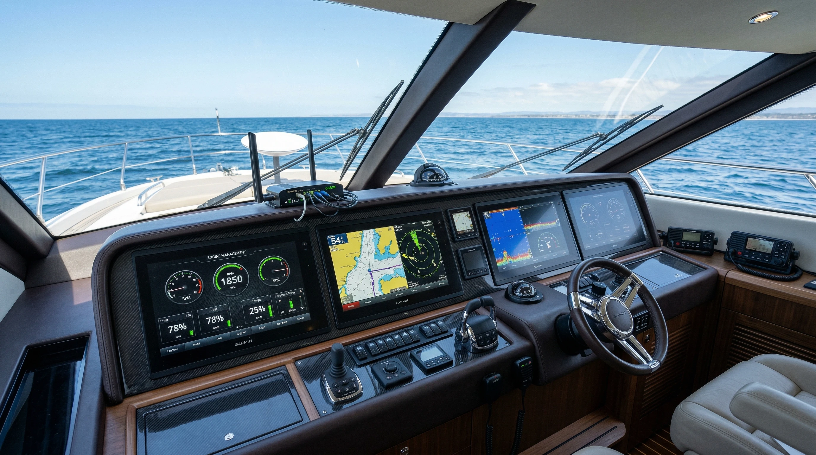
Based on what I’ve seen and tested, the latest marine GPS technology trends are focused on making integration even smoother and more powerful. Many marine GPS units in 2026 use cloud-connected networks to keep chart data and system firmware up to date without lifting a finger. This makes it easier to always have the latest maps, tide charts, and hazard updates without returning to shore to manually update them. Automatic software updates through WiFi, especially when docked at a marina with good coverage, are now fairly common. This creates a seamless way to stay safe and informed.
Another trend is mobile-first design. Most top marine GPS apps are now designed with tablets and smartphones in mind. Manufacturers are embracing wireless data sharing, making it much simpler to dash below deck, pick up a tablet, and keep track of your progress just as easily as you would on a mounted display. I’ve found that this reduces distractions and lets me keep watch with less stress. Marine GPS app integration also supports multicrew collaboration, with friends or family able to send waypoints or share real-time data between devices instantly. As the tech keeps evolving, people are also using their phones for more than just navigation, including controlling music, monitoring engine stats, and even managing anchor alarms, which boosts convenience.
Choosing the Best Wireless Connectivity Options for Boats
When I started upgrading my own boat’s electronics, sorting through the many wireless options was one of the first puzzles I faced. The main types used on most boats today are:
- WiFi: Creates a local area network on your boat, allowing high-speed data sharing between chartplotters, fishfinders, smartphones, and tablets. Some systems, like Garmin’s Marine Network or Raymarine’s WiFi systems, are purpose-built for stable connections at sea.
- Bluetooth: Best for closerange device pairing and lightweight tasks such as audio streaming or small bursts of data sharing between controls and apps.
- Cellular Modems: Let you connect to the internet via mobile networks. This is especially handy for streaming weather reports, downloading chart updates, or syncing with cloud-connected apps like Navionics.
- Satellite: For those who head far off the coast, satellite internet solutions like Iridium GO! or Starlink Maritime provide connectivity well beyond cell coverage. These are more expensive but offer serious coverage and reliability for long crossings.
My own setup combines WiFi for local data, Bluetooth for audio and control tasks, and a cellular modem for wider coverage. Each boat’s requirements are a little different, but making sure your network reaches all corners of the boat is crucial for smooth GPS app integration and safety communications. Double-checking for waterproofing and reliable power supply prevents most of the headaches I faced in the early days of setting up my systems. If you cruise with larger groups or often fish in remote areas, investing in a satellite system can put your mind at ease.
How to Integrate GPS With Marine Apps
Connecting your GPS to your favorite marine apps improves navigation, tracking, and even fishing success. When I first started, the trickiest part was getting different brands to talk to each other. Here’s how I’ve managed to avoid compatibility headaches:
- Know Your Hardware: Before buying any device or app, check which wireless protocols (Wi-Fi, Bluetooth, NMEA 2000, etc.) your GPS unit and chartplotter support. Most top apps list supported hardware on their websites.
- Download the Relevant Apps: Leading marine GPS apps like Navionics, C-MAP, Garmin ActiveCaptain, and Simrad offer free and paid features. Make sure you’re using the correct version for your hardware and that your device’s operating system is up to date.
- Pair and Authenticate: Using WiFi Direct or app-specific QR codes, pair your mobile device with your chartplotter or GPS unit. In my experience, it’s easier to do this at home or at the dock where you have strong and stable connections.
- Sync Routes, Waypoints, and Charts: Good marine apps let you import and export routes. I create my routes on a tablet for the bigger screen, then sync them to the main chartplotter using wireless transfer.
- Use Live Data Sharing: Some advanced setups share real-time boat position, heading, and even engine data between smartphones, tablets, and onboard displays. I use this a lot for fishing, so crew can follow along and help navigate or keep track of conditions.
As the number of integrated apps grows each year, keeping a list of official compatibility resources, like the Navionics compatibility guide or Garmin’s ActiveCaptain resource library, can really save you trouble. If there’s ever an update, downloading it before leaving the marina is the smart move. Recently, I observed that firmware updates can sometimes change the way apps communicate, so a quick test run after updates always helps.
Wireless Connectivity and Marine Safety
Having solid wireless connections and tightly integrated marine GPS apps does more than just add convenience. I learned pretty quickly that these tools also play a really important role in staying safe on the water. Features like instant weather updates, automatic distress calls (DSC), live tracking, and collision avoidance are now part of many of the top marine GPS apps for 2026.
Apps such as Navionics Boating or Garmin ActiveCaptain can send push notifications about changing weather, shallow areas, or restricted zones directly to your smartphone. Some systems let you set up an automatic breadcrumb trail so family or marina staff can see where your boat has traveled and get an alert if you drift off course. During an unplanned foggy return to port last year, I relied on radar overlay features shared wirelessly between my phone and chartplotter to guide me in safely. Also, many new systems now include AIS integration, letting you spot nearby vessels and avoid potential hazards much more efficiently.
I always encourage boaters to use apps that support MOB (man overboard) functions, sending immediate GPS coordinates to everyone in the group, sometimes even over text if you have a cellular signal. The ability to keep everyone connected in an emergency is a big reason I put so much effort into making sure my onboard wireless network works perfectly before every big trip. Practicing safety drills with these systems has made me far more confident on long passages.
Top Marine GPS Apps for 2026
Marine GPS app integration is only as good as the apps themselves. Having tried at least a dozen in the last two years, these are the ones I keep going back to:
- Navionics Boating: Mixes rich chart data, advanced route planning, crowdsourced reports, autorouting, and wireless transfer across devices. It also supports sonar logging and integrates well with Raymarine, Lowrance, and Simrad systems.
- Garmin ActiveCaptain: Connects seamlessly with Garmin chartplotters, shares map updates, routes, and user community info. I especially like the way it handles software updates.
- C-MAP App: Strong on social features, weather overlays, and trip history. It’s especially good for sharing tracks with others and is regularly updated for new features.
- iNavX: Known for supporting many third-party charts and is great for advanced users who want total control over routes and waypoints. It requires more setup but offers serious flexibility.
- Simrad App: Comms directly with Simrad MFDs, supports planning and device control, and is reliable for trip logging and waypoint sharing.
These apps offer cloud backup, wireless syncing, customizable data dashboards, and even weather and tide overlays. Real time traffic monitoring and AIS (Automatic Identification System) overlays are increasingly being included, improving safety for anyone cruising busy waterways. I always make sure to test updates and review their privacy and datasharing settings before relying on them for a season. While some boaters stick to just one app, using a combination has given me the benefits of each and helped me stay ahead of unexpected issues.
Cool Marine GPS App Features Worth Knowing About
Marine GPS app features improve every year, and many functions go beyond just navigation. Here are some of my favorites that I use on a regular basis:
- Autorouting: Enter your start and end points, and the app calculates the safest route using current charts, depths, and navigational warnings.
- Offline charts: Download charts for entire regions ahead of time, so you’re not stranded if you lose signal offshore.
- Community data: Crowdsourced hazard reports and points of interest mean you get updates from other boaters, not just official chart providers.
- Sonar chart overlays: Combine live sonar and crowdsourced depth data to find new fishing spots or avoid running aground.
- Weather and tide integration: I check weather overlays and live tide info before starting any trip; these features have saved me from rough water more than once.

Learning to use advanced features like “follow me” tracking or sharing your live position with friends and family can make group fishing trips more organized and fun. The more you explore these apps, the more options open up for smarter, safer boating. I’ve found that using real-time fuel monitoring in some of these apps has made it much easier to plan longer trips without running out unexpectedly, easing a lot of anxiety on longer voyages.
Challenges and Tips When Integrating Wireless and Marine GPS Tech
Like any tech upgrade, integrating wireless connectivity and marine GPS apps comes with its own set of challenges. In my experience, the following issues stand out:
- Signal interference: Other electronics, especially older VHF radios or radars, can sometimes cause connection drops. Testing things in the marina before heading out saves me a lot of headaches.
- Power limitations: All those wireless devices draw extra power. I always double-check my battery and solar backup before leaving the dock, especially on longer trips.
- Software compatibility: Not all apps play nicely with every GPS unit. Double-checking compatibility charts and running firmware updates keeps everything running smoothly.
- Cybersecurity: Connecting more devices introduces more risk. I use strong passwords on all WiFi and disable unused Bluetooth connections, just to be safe.
Plenty of these problems are easy to handle with a bit of planning. Setting up your network at home and running a quick trial trip around local waters gets everything working before you’re relying on it out at sea. And after a few seasons, troubleshooting these systems gets a lot less intimidating.
Everyday Uses, How Wireless Marine GPS Integration Helps Onboard
Wireless marine GPS integration has found its way into many everyday boating situations. I’ve used cloudsynced waypoints to return to rarely fished wrecks, shared charts with friends planning group trips, and even kept track of sail racing progress right from my phone. When you’re docking in a tight marina, seeing your exact heading, wind info, and live charts on a tablet makes things less stressful. If your crew brings their own tablets or smartphones, they can follow along without crowding around the main display. This has added to the fun and safety of my outings more than any other gadget I’ve tried. Using wireless integration to keep all this data synced has made maintenance easier, service teams can access route logs and diagnostics right from their mobile device.
Frequently Asked Questions
Here are a few questions I get asked by other boaters and friends looking to go wireless on the water:
Question: What’s the easiest way to get started with marine GPS app integration?
Answer: Start simple; use your smartphone or tablet with a recommended marine GPS app like Navionics or C-MAP. Connect it to your chartplotter or GPS unit via WiFi or Bluetooth, and practice using key features before taking a big trip. Spend some time exploring the app at home and try plotting a route or setting waypoints to get comfortable before you trust it with more complex navigation.
Question: Is wireless marine GPS connectivity safe and reliable for offshore use?
Answer: With proper hardware and setup, WiFi and cellular networks work well within cell range. For offshore cruising, consider satellite solutions for backup, and always download offline charts in case you lose your connection. Testing your setup during a short trip before heading far offshore can help you spot potential issues early.
Question: Can I share routes and waypoints between devices wirelessly?
Answer: Most new marine GPS units and apps support wireless transfer of routes, waypoints, and even live position sharing. Just check your hardware compatibility before planning an important route. For frequent users, using cloud backup is also helpful if you ever need to restore your data.
Question: What are the major security concerns with connected marine systems?
Answer: The biggest risks are from unsecured WiFi networks and weak passwords. Always use strong, unique passwords for your boat network and keep software up to date. Setting devices to not automatically connect to unknown networks also adds a layer of safety.
Wrapping Up
Linking wireless connectivity with marine GPS app integration adds new levels of comfort, safety, and fun to life on the water. Staying informed about the latest marine GPS technology and the best wireless connectivity options for boats has made my time at sea smoother and less stressful. Smart planning, choosing the right hardware, and regular testing mean smoother trips and safer adventures, no matter where you go. If you’re just starting, try a basic app and a reliable wireless setup, and keep exploring more advanced features as you gain confidence. As technology advances quickly, making the most of these tools will keep every adventure safe and enjoyable.
This article was created with AI assistance and reviewed by a human editor.
About The Author


Technology has improved so much with these GPS navigation systems if you compare them with a few years ago. Companies really have to keep up with the pace to ensure their devices stay on top.
I think that the best marine GPS navigation systems for 2026 seem to be those made by Garmin, (GPSMAP/ECHOMAP). They seem to offer high-resolution screens, advanced sonar, and detailed mapping for navigation and fishing, and Garmin is often cited for its user-friendly interface and comprehensive ecosystem. What are your favorites?
That’s a solid take, and I agree, Garmin really does dominate the conversation right now, especially with the GPSMAP and ECHOMAP lines. They’ve built a reputation for reliability and an ecosystem that just works, which is a big deal on the water.
Personally, I think your picks are right at the top, but what’s interesting is how the “best” system really depends on how you use it.
For example, newer Garmin units stand out because of their integration and mapping. Many models come with built in charts or support advanced mapping like Navionics+, and they can even share data across devices on the same network (Garmin Support). That kind of connectivity is a huge upgrade compared to older standalone GPS units.
At the same time, there are a few other brands I’d put in the conversation:
Simrad (GO / NSS series) – Great for offshore cruising and more advanced setups. Often praised for radar and integration with larger vessels.Raymarine (Axiom series) – Strong in touchscreen performance and real-time navigation features like augmented reality overlays.Humminbird (HELIX / SOLIX) – Especially popular with anglers because of their sonar and imaging tech.
Interestingly, even among users, Garmin still tends to come up as the “safe choice.” One Reddit user mentioned that if you plan to expand your setup (like adding live sonar), going with Garmin makes sense because of compatibility and ecosystem advantages (Reddit).
If I had to pick favorites:
Best all-around: Garmin GPSMAP series (powerful, expandable)Best for fishing: Garmin ECHOMAP Ultra or Humminbird HELIXBest for offshore/nav-heavy use: Simrad NSS or Raymarine Axiom
So yeah, Garmin is definitely leading, but it’s less about one “best” unit and more about what kind of boating you’re doing.
Curious, are you more into fishing, cruising, or commercial use? That usually changes the answer quite a bit.