Marine GPS and Automatic Identification System (AIS) technology has completely changed how I find my way and stay safe on the water.
These systems help with everything from real time location tracking to identifying nearby vessels for collision avoidance. Since there are plenty of choices on the market, understanding the core features and benefits can really help when upgrading a current system or making your first purchase. In this article, I’ll break down the marine GPS features and AIS benefits that matter most, compare top AIS systems for boats, and highlight key technology trends so you can make the right choice for your vessel.
Getting to Know Marine GPS and AIS Technology
Marine GPS (Global Positioning System) helps pinpoint a vessel’s exact position anywhere on the globe by using satellites. It’s the backbone of modern boat navigation, used by both recreational sailors and commercial mariners. GPS units provide important data like speed, heading, waypoints, and weather overlays, making plotting and route planning much easier and safer. (NMEA International Resource)
The Automatic Identification System, or AIS, is a tracking system that swaps information between vessels and shore stations. It shares data such as identification, position, speed, heading, and destination. When I’m on the water, AIS lets me see other nearby boats, even in low visibility or crowded waterways. This shows up directly on my chartplotter or navigation display, making it far easier to spot other vessels when the weather doesn’t cooperate.
Core Marine GPS Features
Today’s marine GPS models have far more than just position data. Some features I rely on include:
- Chartplotting: The ability to put digital navigation charts together with your rea time location for easier course setting.
- Waypoint Management: Mark and save key locations, fishing spots, or hazards for future trips.
- Route Planning: Cook up and store complex routes, with guidance you can fine tune along each leg.
- Depth Sounding Integration: Many systems sync with sonar/fishfinder technology for depth and bottom contour data.
- Weather Alerts: Some include integrated weather updates or overlays so I know what’s ahead of me.
- Touchscreen Displays: Modern units offer sharp graphics and intuitive controls, much like a smartphone.
- Connectivity: WiFi, Bluetooth, and NMEA 2000 support make it easy to hook things up with autopilots, radar, and mobile devices.
- Backup and Sharing: Syncing routes and waypoints across different devices or sharing data with fellow boaters.
These marine GPS features have proved really useful on family trips, fishing charters, or even relaxing day sails when visiting favorite spots or steering clear of hazards in unfamiliar waters.
Main Benefits of Automatic Identification System (AIS)
AIS isn’t just for commercial ships. Recreational boaters use it more than ever. Here’s why AIS has become such a helpful addition to my gear:
- Collision Avoidance: With real time display of surrounding vessels, I can steer clear of busy or dangerous areas, whether in fog or at night.
- Vessel Identification: Instantly view details such as name, type, size, speed, and course of nearby ships.
- Situational Awareness: AIS data makes it easier to keep tabs on anchored boats, track ferries on busy routes, and identify fastmoving craft.
- Distress Alerts: Many systems can send or receive emergency signals, helping rescue crews spring into action fast.
- Shore Tracking: Ports and harbors use AIS for traffic control and vessel management, so my approach is smoother and safer.
The automatic identification system benefits any skipper who wants a clearer view of their surroundings, especially in crowded or hightraffic waterways where quick reactions matter.
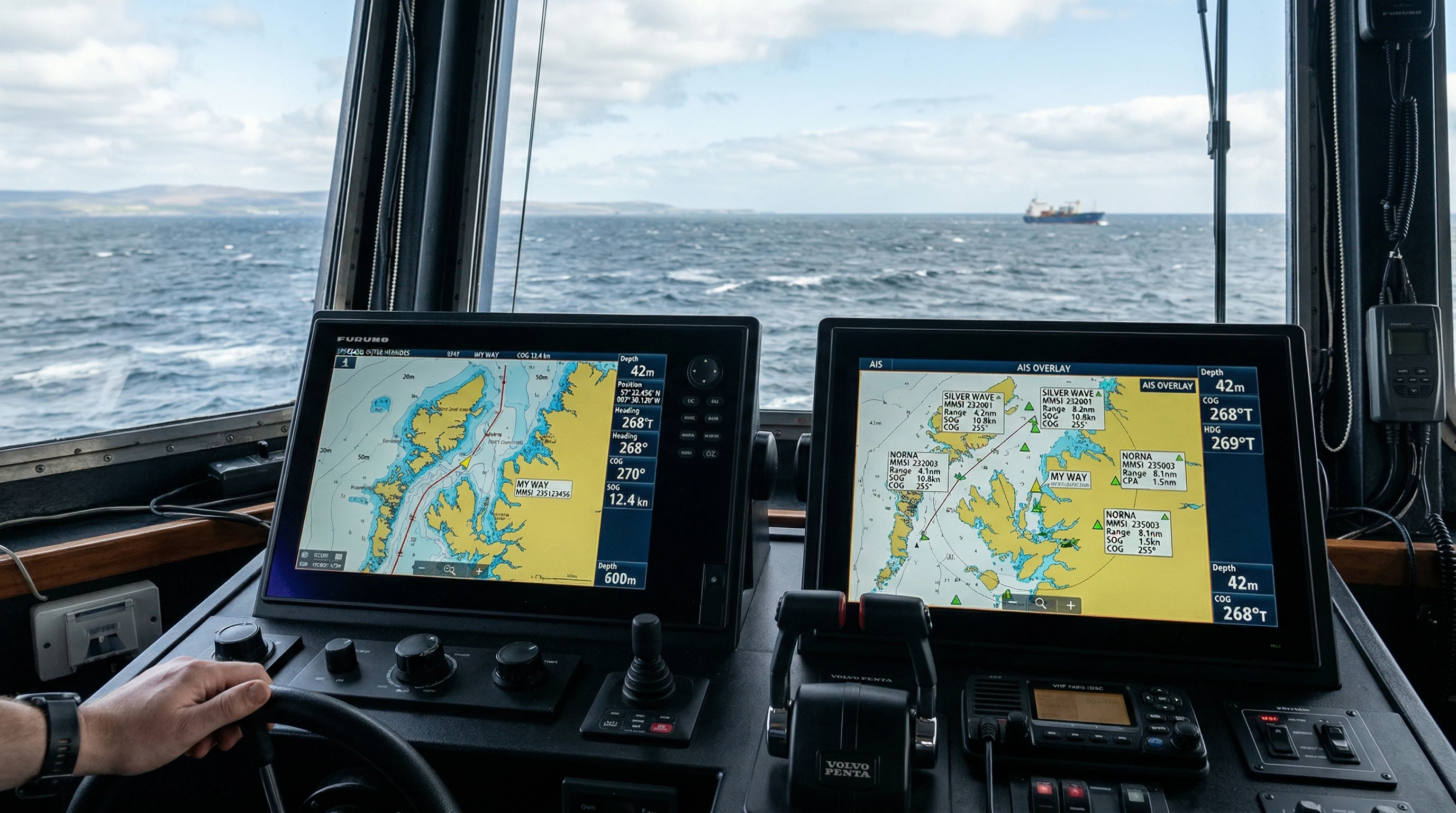
Marine GPS and AIS, How They Work Together
Most larger displays and chartplotters now combine marine GPS with AIS. I see my own boat’s position along with all the nearby AISequipped vessels on one interactive chart. This blended approach lets me:
- Quickly spot the risk of collision by seeing heading lines and CPA (closest point of approach) predictions.
- Select any AIS target to view full vessel details and see its movement history.
- Overlay weather, radar, sonar, and navigation data with vessel traffic for total awareness.
- Receive pop up warnings if another vessel approaches too closely based on preset settings.
Marine GPS with real time tracking gives real peace of mind, whether boating in busy coastal areas or quietly anchoring on a foggy morning.
Comparing Top AIS Systems for Boats
Choosing the right AIS comes down to how you use your boat and which features matter most. I’ve used AIS both solo and as part of a commercial crew, and the difference in systems can be dramatic.
- Class A AIS: Used on commercial vessels, tankers, and large ships. Broadcasts more frequently, with higher transmit power (12.5W), and is required by law on SOLAS class vessels. Offers priority in crowded areas and supports extra statuses like “not under command.”
- Class B AIS: This suits recreational sailors, fishing boats, and smaller workboats. Lower transmit power (2W or 5W) and transmits less often. Still provides regular position updates, vessel details, and works with nearly all chartplotters.
- AIS Receivers Only: These receive data from other ships but don’t send out your own vessel info. Good for those who want to watch traffic but don’t need to be seen themselves.
- AIS MOB (Man Overboard) Beacons: Small, personal tools that send a distress alert if someone goes overboard. Plug and play with many modern AIS receivers.
Some of the top AIS systems for boats include Simrad, Raymarine, Garmin, and Vesper Marine. Garmin’s GPSMAP series and Vesper’s Cortex hubs bring some of the most advanced integration and alerting options. For commercial work, Class A systems from Furuno and McMurdo deliver reliability and compliance that is required by law. See the U.S. Coast Guard AIS Resource for official information and compliance details.
Comparing Marine GPS and AIS Features
I often get asked how marine GPS and AIS features stack up. Here’s how I see the overlap and distinctions:
| Function | Marine GPS | AIS |
|---|---|---|
| Position Tracking | Shows your boat’s position | Shows all nearby AISequipped vessels’ positions |
| Route Planning | Full chartplotting and waypoints | Not available |
| Collision Avoidance | Based on chart overlays and alarms | Graphs other vessels’ speed, heading, CPA/TCPA alerts |
| Weather and Depth | Often supported | Not supported directly |
| Communication | GPS only, not interactive | Transmits and receives vessel data |
On their own, GPS and AIS each provide key data. Blended together, they really boost safe navigation and route planning, especially when navigating busy waterways.
Trends in Marine GPS and AIS Technology by 2026
I keep a close watch on tech improvements, and some great marine GPS technology trends for 2026 are already showing up:
- Smarter Integration: Newer multifunction displays (MFDs) tie GPS, AIS, radar, sonar, and even engine data into a single network, making information sharing onboard easier than ever.
- Real-Time Global Tracking: Advances in satellite AIS provide near real time tracking of vessels worldwide, which is great for fleet operators and longrange cruisers.
- AI-Powered Collision Avoidance: Some AIS and GPS combos now use artificial intelligence to predict collision risk with data from vessel performance and environmental sources.
- Mobile Device Expansion: GPS and AIS apps for phones and tablets let me monitor my boat from shore or carry my navigation anywhere, which is handy for small craft.
- Better Power Efficiency: With solar and battery tech growing quickly, allinone portable units are way lighter and longer-lasting for those offgrid trips.
- Cloud Data Backups: Saving trip logs and maintenance data to the cloud means I can restore, share, or keep important info safe.
- Cybersecurity Features: With more connectivity, new AIS and GPS systems now focus more on encryption and privacy features to keep vessel locations and operations protected.
These upgrades will keep making marine navigation safer, more accessible, and even more fun for both commercial crews and casual weekend cruisers. See International Maritime Organization (IMO) for the latest updates.
Best AIS Options for Commercial and Recreational Use
For commercial vessels, picking a top level Class A AIS with strong compliance and global coverage is really key. Furuno, McMurdo, and Saab offer options that plug right into radar, ECDIS, and VHF radios. These meet SOLAS requirements and are built with backup solutions for all weather operation.
For recreational or club boats, it’s worth checking out Class B transceivers from Vesper Marine, Raymarine, or Garmin. These are much easier to install, use less power, and work well with most chartplotters. Many also support firmware updates and remote monitoring, including anchor alarms and text or email status alerts.
If you only need a simple way to see nearby ships without broadcasting your position, a dedicated AIS receiver is a good choice, especially for sailors on busy inland waterways or lakes where being seen is less critical.
Real Life Applications and Safety Improvements
I’ve been in situations where AIS truly made the difference. On a foggy morning near the coast, I could spot a commercial freighter long before it was visible, giving me plenty of time to change course. For rescue operations, AIS MOB devices are now standard; crew members carry them on their vests so if someone falls overboard, any AISequipped vessel nearby receives their position and can respond even faster.
Most recreational boaters also appreciate real time GPS tracking combined with AIS overlays, especially when navigating new waters, at night, or in busy harbors. This technology has played a huge part in lowering collision incidents worldwide, according to reports from the U.S. Coast Guard and ECDIS Information Portal.
Things to Consider When Choosing Marine GPS and AIS
A few practical tips help make sure you pick the best system for your needs:
- Vessel Size and Power Supply: Large boats with strong electrical systems can handle premium AIS transceivers and big screens, small craft need lightweight, batteryfriendly options.
- Integration with Existing Equipment: Making sure NMEA 2000 compatibility is present lets you easily plug new devices into autopilot, radar, and depth sounder networks.
- Type of Boating Activity: Offshore or commercial work needs Class A AIS, while day sailors and anglers will likely be happy with Class B.
- Display Preferences: Large touchscreen MFDs are top-notch for helm stations, while handheld GPS and mobile apps work beautifully for dinghies and tenders.
- Software Updates and Support: Look for brands that regularly update their software and offer good support for any issues.
- Budget: More features mean higher prices. Simple receivers start below $200, while pro grade Class A kits for commercial ships run into the thousands.
Careful research makes it easier for buyers to choose based on their unique needs, onboard gear, and future boating adventures.
Backup Power and Antenna Placement
Even the best marine GPS or AIS system won’t do you much good if it loses power or struggles with signal. I always bring a backup power source or an extra battery pack, especially on longer rides. Antenna placement really counts too, higher and unobstructed positions help max out your range and reliability for both GPS and AIS signals.
Frequently Asked Questions
I hear these questions all the time from boaters considering a move to GPS or AIS tracking:
Question: Can I use GPS without AIS or vice versa?
Answer: Yes, you can. GPS helps you steer and chart your route, while AIS isn’t usually required for small pleasure boats in most regions. Using both together really steps up safety and awareness, though.
Question: What’s the best AIS for commercial vessels?
Answer: A certified Class A AIS with display options from brands like Furuno or McMurdo is usually best. These kits offer legal compliance, better range, and provide frequent updates for commercial shipping areas.
Question: How does AIS improve maritime safety?
Answer: AIS gives real-time tracking and IDs for all the ship traffic nearby, cutting collision risks and letting responders act fast in emergencies. If you send out an AIS distress signal, both authorities and other boats can quickly find your position.
Question: Are there subscription fees for marine GPS or AIS?
Answer: Most GPS devices don’t need a monthly fee, but fancier digital charts and some weather options might. AIS uses VHF radio, so there are usually no subscription costs, except for highend satellite AIS tracking aimed at large fleets or ocean ventures.
Why Upgrading to Modern Marine GPS and AIS Is Worth It
Combining the latest marine GPS features with top-notch AIS tech has made boating safer and more enjoyable for me and many others. The option to see my position, plan crossings, and spot other boats in real-time brings peace of mind in busy areas or bad weather. With these upgrades becoming more affordable, even small boats can tap into tools once only available on cargo ships. Smart research, checking your current gear, and planning for future add-ons will help you make the most of your investment. Whether cruising with family or running a work vessel, these upgrades really make a difference for safety and enjoyment out on the water.
This article was created with AI assistance and reviewed by a human editor.
About The Author


